![[Medieval Map of the Holy Land] By Anonymous](https://storage.googleapis.com/raremaps/img/small/94822.jpg)


|
||

|

|
|

|
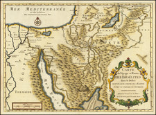
French Edition of the First Printed Map of the Holy Land -- The Burchard of Mt. Sion Map of circa 1280
Decorative example of an early-sixteenth century print of Burchard of Mt. Sion's medieval map of Palestine, which was first printed in Lucas Brandis's Rudimentum Novitiorum sive Chronicarum Historiarum Epitome (Lübeck, 1475) . The 1475 example was the first printed map of the Holy Land and one of the first maps ever printed.
Like other medieval maps, the geographic representation is intended to be relative, rather than geographically accurate. The map is east-oriented, with Jerusalem in the middle, as it was the spiritual epicenter of Judeo-Christian life. Radiating outward in all directions are hills with the names of cities, towns, and geographical features of biblical and medieval significance. Buildings are white with red roofs, and pathways that pass between the hills are crowded with small figures walking or riding. Ships are sailing in the Mediterranean, to the west (bottom of map), and eight wind-heads blow their gales across Palestine and the wider region.
The map is full of biblical imagery. In the upper right is Mt. Sinai, where Moses is receiving the Ten Commandments. The Red Sea snakes down to Egypt, in the bottom right corner, and is filled with armor and a drowning king. This is perhaps a reference to the Pharaoh's army, lost after the waters swept in after the Israelites had passed. The Dead Sea, to the east, has spires peeking from its depths, the remains of Sodom and Gomorrah. Jesus is being baptized by John the Baptist in the River Jordan. Near to Jerusalem, at Calvary, Jesus is hanging on the cross.
The Burchard of Mt. Sion Map
Burchard of Mt. Sion was a Dominican friar, who most likely hailed from Magdeburg in what is now northern Germany. From ca. 1274 to 1284, he travelled the Middle East, visiting the main Christian pilgrimage sites. He was one of the last pilgrims to do so before the fall of the Latin Kingdom in 1291.
Burchard wrote of his travels and the work circulated in manuscript under the name Descriptio Terrae Sanctae. It was also translated into French and German and today the manuscript copies are treasures of several institutions including the Bodleian Library, the Bibliotheque Nationale, and the Royal Library of Belgium. As Baumgertner explains, it is "a key document that influenced the perception of Palestine in both text and image, in travel accounts and maps until far into the sixteenth century" (p. 8).
Roughly 100 copies of the manuscript survive today, in a short and long from. The latter is known as the Prologus. In the description, Burchard described the geography of the region and gave distances, in leagues, between the principal cities. According to Nebenzahl, this makes Burchard the first to share a survey of the distance and directions of the Holy Land. However, the map upon which this printed version is based that was supposedly circulated with the description has not survived.
Although the lost map cannot be examined by today's scholars, vestiges of its influences are known. Medieval geographers like Sanuto and Vesconte, Wey, Capodilista and others mention the map and give its main features. They also repeat Burchard's erroneous hypotheses, particularly the interconnected riverine system he championed, which had the Jordan River flowing south, beyond the Dead Sea, into the desert, as seen on this example. Additionally, they replicate the incorrect location of Corazim on the northeast shore of the Sea of Galilee. Burchard mentions the false location in his description and it was likely also in his map.
Lucas Brandis and the Rudimentum Novitiorum
Lucas Brandis included a copy of the map is his famous Rudimentum Novitiorum, an encyclopedia of Christian theology and history. The work was intended as a concise library of information for those men too poor to buy many books. The two maps included, one of which is this map, are the first printed maps. While Isidore of Seville had included a T-O projection in his encyclopedia of 1472, it lacks the detail and rich content of these examples. The first edition of Ptolemy's work to include maps would not be printed until 1477, in Bologna. Interestingly, it is also one of the only printed maps to show a medieval worldview, as opposed to an early modern conception of the world based on Ptolemy's grid.
In the Rudimentum Novitiorum, Brandis included an abridged version of the Bible, a history of the popes and rulers who fought for Christianity, and Burchard's Prologus. It is likely that Brandis himself prepared the wood cut block with the two maps, which included this one of the Holy Land and another of the world as it was then known.
Brandis only arrived in Lübeck with his press in autumn of 1474, and the Rudimentum Novitiorum was published as a two-volume folio by August 5, 1475-an extraordinarily rapid production time for the period. After its original publication in Latin, the work was translated into French as Mer des Hystoires in 1488 (Pierre Le Rouge, Paris). Re-issues of the first French edition continued to be printed from 1517-1555. This is therefore a fine, decorative example of the re-issue of the first map of the Holy Land ever printed.
Ingrid Baumgartner, “Burchard of Mount Sion and the Holy Land” Peregrinations: Journal of Medieval Arts and Architecture 4 (2013): 5-41.
![[ Arabian Peninsula ] Sexta Asie Tabula](https://storage.googleapis.com/raremaps/img/small/80372.jpg)
![(Second World War - Oilfields) Vorderasien mit seinen Erdölgebieten [Western Asia with Its Oil Fields]](https://storage.googleapis.com/raremaps/img/small/87373.jpg)