|
||

|

|
|

|
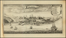
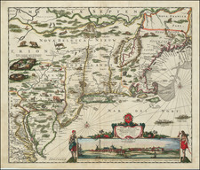
Remarkable Battle Plan of the Siege of Quebec. One of the Greatest 18th Century Plans of Quebec.
Finley executed map of the Battle of the Plains of Abraham produced by geographer Thomas Jefferys, including the rare second plate, which shows the progress of the battle on the Heights of Abraham.
Prepared by Jefferys for the British Crown, the map was drawn from the original surveys taken by the Engineers of the Army.
The map shows the location of French and British troops, artillery and ships, with a list at the bottom right locating the camps of the military leaders during the Siege. The second folding paste down plate at the right shows the progress of the battle.
The map illustrates the ships of Admiral Charles Holmes's division, including Sea-horse, Squirrel, Lowestoffe, and Hunter. The ships of Admiral Sir Charles Saunders's division are also shown though not individually named.
The camps of Brigadier Robert Monckton, Major General James Wolfe, and Major Hardy are all shown and the map is extended so that they can be shown.
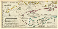
General Topography of North America and the West Indies
The present map comes from Thomas Jefferys' supremely important atlas of North America and the West Indies, titled General Topography of North America and the West Indies. The atlas is certainly the scarcest of the great 18th century atlases of America. It substantially surpasses Faden's North American Atlas, Jefferys' American Atlas, and Des Barres' Atlantic Neptune, in rarity. In many respects, it also surpasses those atlases through the inclusion of maps that are not to be found anywhere else. The atlases has only appeared once on the market in the last 80 years, with a defective copy making 8,000 GBP at Sotheby's in 1971.
Rarity
The map is rare on the market, especially with the extra panel, which is frequently lacking.
Thomas Jefferys (ca. 1719-1771) was a prolific map publisher, engraver, and cartographer based in London. His father was a cutler, but Jefferys was apprenticed to Emanuel Bowen, a prominent mapmaker and engraver. He was made free of the Merchant Taylors’ Company in 1744, although two earlier maps bearing his name have been identified.
Jefferys had several collaborators and partners throughout his career. His first atlas, The Small English Atlas, was published with Thomas Kitchin in 1748-9. Later, he worked with Robert Sayer on A General Topography of North America (1768); Sayer also published posthumous collections with Jefferys' contributions including The American Atlas, The North-American Pilot, and The West-India Atlas.
Jefferys was the Geographer to Frederick Prince of Wales and, from 1760, to King George III. Thanks especially to opportunities offered by the Seven Years' War, he is best known today for his maps of North America, and for his central place in the map trade—he not only sold maps commercially, but also imported the latest materials and had ties to several government bodies for whom he produced materials.
Upon his death in 1771, his workshop passed to his partner, William Faden, and his son, Thomas Jr. However, Jefferys had gone bankrupt in 1766 and some of his plates were bought by Robert Sayer (see above). Sayer, who had partnered in the past with Philip Overton (d. 1751), specialized in (re)publishing maps. In 1770, he partnered with John Bennett and many Jefferys maps were republished by the duo.