|
||

|

|
|

|
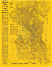
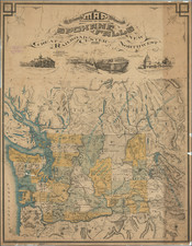
Uncommon pamphlet map of the city of Seattle, from the 1910s, showing the grid layout of the city and the extent of streetcar line development. The map stretches from Green Lake in the north down to Georgetown and South Park in the south. Neighborhoods, parks, places of interest, and more are named.
The map can be dated to 1917 or 1918, as it shows both a completed Lake Washington Canal between Lake Union and Salmon Bay (completed in 1917) and still cites the Seattle Electric Company as owning railroad lines (it was bought out by the municipal government in 1918.
The verso of the map includes text describing the "Seeing Seattle" streetcar, a popular early tourist attraction that begin in the first decade of the 20th century. The draws for Fort Lawton and Alki Point are also noted.
We have been unable to trace other examples of this map as having appeared on the market.