|
||

|

|
|

|
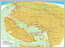
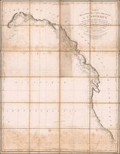
Shows The "Disputed Territory" in Western British Columbia
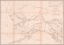
Fine large map of the Alaska and contiguous parts of British Columbia, promoting the Canadian Pacific Railway routes to the Yukon and Klondike mining regions in 1898.
Published to promote overland transit from Canada to the gold fields, the map shows the Canadian Pacific's primary terminus points in Edmonton, Prince Albert, and Vancouver, each illustrating different routes to the mining regions in Alaska and the Yukon. The most Northerly route, via Slave Lake and the MacKenzie River to the Porcupine River and ultimately the Yukon River is shown, as are shorter overland routes via Fort Selkirk.
The Dalton Trail is specifically named.
The moist noteworthy feature of the map is a gray area beginning in the south near Mary's Island and Ketchikan and extending beyond Skagway to the area near Mt. St. Elias and Mt. Logan, which is shaded grey. This would be the area which would be the subject matter of the Alaska boundary dispute, a territorial dispute between the U.S. and Britain, which would not be resolved until 1903. The dispute has its genesis in as between Russia and Britain since 1821, with the U.S. succeeding to the Russian claims after the Alaska Purchase in 1867. The dispute intensified with the discovery of gold in the region, making control of the coastal and inland waterways in the disputed territory much more important than before 1897. The final resolution favored the US, with Britain failing to obtain an all-Canadian outlet from the Yukon gold fields to the sea.
Rarity
The map is very rare. We note examples in the Bibliothèque et Archives nationales du Québec and Universite Bordeaux Montaigne.
![(Canadian-American Boundary) [Group of 11 photographs by Alexander Gardner, including 3 after the British Commission's 1860-61 photographs, for the North American Boundary Commission Survey along the 49th Parallel, used in settling Hudson's Bay Co. claims in the British and American Joint Commission]](https://storage.googleapis.com/raremaps/img/small/95481.jpg)