|
||

|

|
|

|
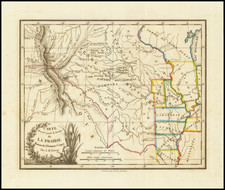
Fine example of the second appearance of this important map from the 1835 Dodge-Kingsbury expedition.
The map traces the Dodge expedition's route from Ft. Leavenworth to the Platte, through the Kickapoos and Otoes Territories, west to Grand Island and the Pawnee Village, past the Medicine Lodge of the Rees and to the foot of the mountains, which notes Snakes and Crow's War Ground. The party then continued south and later west of the Gros Ventres Indians, past Fontaine que Bouilloit and Pike's Peak to the Arkansas River, then to Bent's Trading House between the Comanche and Chienne lands. Wheat speaks highly of the map, which draws on Everrett's 1834 report and McCoy's 1832 manuscript Indian Lands map.
First published in 1836 in an edition of 500 for Congress, this 1861 edition is also increasingly scarce on the market.
![[Mormon Trail] Utah And the Overland Routes to it, from the Missouri River: Published with](https://storage.googleapis.com/raremaps/img/small/66366.jpg)