


|
||

|

|
|

|
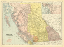
Promoting British Columbia
Fine large format map of British Columbia, published by the Provincial Board of Information.
Lieutenant Palmer's Trail is noted, a reference to the explorations and surveys of Lieutenant Henry Spencer Palmer, an engineer who undertook multiple surveys in the province under the auspices of the Royal Engineers as part of the British Columbia Expedition from its beginning in 1858 until it was disbanded in 1863 The map also notes the proposed route of the Grand Trunk Pacific Railway, with its terminus at Prince Rupert and an alternate route with a terminus at Kitimat at the head of the Douglas Channel.
The map presents an exceptional overview of the Indian Villages, steamboat routes, wagon roads, railroads, mining districts and Dominion Government Reserves in British Columbia. In addition to mining related information, a number of good grazing areas are noted, especially around Oosta Lake Country.
This would seem to be the second state of the map, which was previously issued with significantly less information in 1904.
Rarity
The map is quite rare on the market. We were unable to locate any examples in dealer catalogs or auctions.
![(Nothern Half) [Bancroft's Map of the Pacific States]](https://storage.googleapis.com/raremaps/img/small/54924.jpg)
