


|
||

|

|
|

|
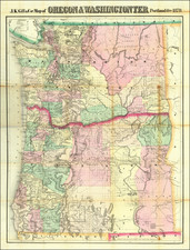
First Edition.
Scarce Gill map of Oregon and Washington Territory (more often the Gill maps focus on one or the other), published in Portland in 1878.
This beautiful hand-colored lithographed map shows early large county configurations, railroads, and communities.
Seattle has only the shortest of railroads connecting the city to Renton and coal mines on the east side of Lake Washington. The map notes the proposed route of the Northern Pacific from Walla Walla.
At the time, Portland, Oregon, was more of a center of commerce and is here shown with long railroad connections through the Willamette Valley, not yet completed to connect to California.
Rarity
Scarce. This is the first time we have had the map. Rumsey (1891) has the 1884 edition, which he notes has been substantially changed from the 1878. OCLC locates examples at Harvard, Yale, Oregon State, Oregon Historical, UC Berkeley, Stanford, and a few other institutions.
The last example we trace in the market was the Heckrotte copy, which sold for $2,280 in 2015.
![[Map of the United States, illustrating the routes of the Canadian Pacific Railway and the Seattle, Lake Shore and Eastern Railway]](https://storage.googleapis.com/raremaps/img/small/71080.jpg)

![[ Pacific Northwest - Northwest Passage ] Limes Occidentis Quivira et Anian. 1597](https://storage.googleapis.com/raremaps/img/small/71207.jpg)