|
||

|

|
|

|
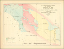
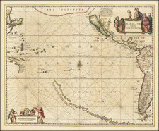
An Exceptional Example of Goos's Iconic Chart of the Island of California
Finely colored gold-heightened example of Pieter Goos' highly coveted map of California as an island, with its contiguous regions. The present example is laid on a second sheet of paper, as issued, for greater durability and use at sea, as was often the case with deluxe copies of the Goos's Zee-Atlas Ofte Water-Wereld . . .
This highly-detailed sea chart is one of the best illustrations of the island of California and one of only a couple of large format maps to focus on the feature. It is also one of the first sea charts of the island. For these reasons, Goos' map is perhaps the most sought after of all maps of California as an island, along with the extremely rare Joannes Van Loon chart using the same configuration.
Tooley referred to the map as, "Perhaps the most attractive and certainly the most definite representation of California as an island. California is the centre and 'raison d'etre' of the map" (map 22, plate 37). Burden agrees, calling it “one of the most desirable of all California as an island maps” (map 391). It is featured on the cover of McLaughlin and Mayo's authoritative The Mapping of California as an Island checklist and is probably the most recognizable map of the genre.
The chart is half filled with the Pacific Ocean, which is criss-crossed with rhumb lines and dotted with a compass rose and two ships in full sail. In the lower left is the scale which is framed by two putti holding dividers and a cross staff. In the upper right corner is the title cartouche, with three putti and floral garlands surrounding the ornate frame.
California is shown on the second Sanson model, otherwise known as the Fox form. To the north is a large island with an open border to the west, perhaps denoting that it could be a continent. It is labeled as “Terra Incognita”, with the Dutch equivalent, “Onbekendt Landt”, below. Separating this unknown land from the North American mainland is the Strait of Anian.
Anian derives from Ania, a Chinese province on a large gulf mentioned in Marco Polo’s travels (ch. 5, book 3). The gulf Polo described was actually the Gulf of Tonkin, but the province’s description was transposed from Vietnam to the northwest coast of North America. The first map to do so was Giacomo Gastaldi’s world map of 1562, followed by Zaltieri and Mercator in 1567. The Strait then became shorthand for a passage to China, i.e. a Northwest Passage. It appeared on maps until the mid-eighteenth century.
Goos chooses to call the mainland New Granada, as opposed to New Spain. California contains several recognizable toponyms, including San Diego (“P. de S. Diego”), and Drake's Bay (“P S. Francisco Draco”). However, all are placed incorrectly relative to their actual positions.
The map first appeared in 1666 in Goos’ De Zee Atlas ofte Water-Weereld (Amsterdam). The Zee Atlas was re-issued in 1668, 1669, 1670, 1672, 1675, and 1676. It was also published in a French edition in 1679 and 1697, with an English edition in 1668 and a Spanish in 1669.
An essential map for California collectors.
The popular misconception of California as an island can be found on European maps from the sixteenth through the eighteenth centuries. From its first portrayal on a printed map by Diego Gutiérrez, in 1562, California was shown as part of North America by mapmakers, including Gerardus Mercator and Abraham Ortelius. In the 1620s, however, it began to appear as an island in several sources. While most of these show the equivalent of the modern state of California separated from the continent, others, like a manuscript chart by Joao Teixeira Albernaz I (ca. 1632) now in the collection of the National Library of Brasil shows the entire western half of North Americas as an island.
The myth of California as an island was most likely the result of the travel account of Sebastian Vizcaino, who had been sent north up the shore of California in 1602. A Carmelite friar, Fray Antonio de la Ascensión, accompanied him. Ascension described the land as an island and around 1620 sketched maps to that effect. Normally, this information would have been reviewed and locked in the Spanish repository, the Casa de la Contratación. However, the manuscript maps were intercepted in the Atlantic by the Dutch, who took them to Amsterdam where they began to circulate. Ascensión also published descriptions of the insular geography in Juan Torquemada’s Monarquia Indiana (1613) (with the island details curtailed somewhat) and in his own Relación breve of ca. 1620.
The first known maps to show California as an island were on the title pages of Antonio de Herrera’s Descripción de las Indias Occidentales (1622) and Jacob le Maire's Spieghel Der Australische Navigatie (1622). Two early examples of larger maps are those by Abraham Goos (1624) and another by Henry Briggs, which was included in Samuel Purchas’ Hakluytus Posthumus or Purchas his Pilgrimes (1625). In addition to Briggs and Goos, prominent practitioners like Jan Jansson and Nicolas Sanson adopted the new island and the practice became commonplace. John Speed’s map (1626-7), based on Briggs’ work, is well known for being one of the first to depict an insular California.
The island of California became a fixture on mid- and late-seventeenth century maps. The island suggested possible links to the Northwest Passage, with rivers in the North American interior supposedly connecting to the sea between California and the mainland. Furthermore, Francis Drake had landed in northern California on his circumnavigation (1577-80) and an insular California suggested that Spanish power in the area could be questioned.
Not everyone was convinced, however. Father Eusebio Kino, after extensive travels in what is now California, Arizona, and northern Mexico concluded that the island was actually a peninsula and published a map refuting the claim (Paris, 1705). Another skeptic was Guillaume De L’Isle. In 1700, De L’Isle discussed “whether California is an Island or a part of the continent” with J. D. Cassini; the letter was published in 1715. After reviewing all the literature available to him in Paris, De L’Isle concluded that the evidence supporting an insular California was not trustworthy. He also cited more recent explorations by the Jesuits (including Kino) that disproved the island theory. Later, in his map of 1722 (Carte d’Amerique dressee pour l’usage du Roy), De L’Isle would abandon the island theory entirely.
Despite Kino’s and De L’Isle’s work, California as an island remained common on maps until the mid-eighteenth century. De L’Isle’s son-in-law, Philippe Buache, for example, remained an adherent of the island depiction for some time. Another believer was Herman Moll, who reported that California was unequivocally an island, for he had had sailors in his offices that claimed to have circumnavigated it. In the face of such skepticism, the King of Spain, Ferdinand VII, had to issue a decree in 1747 proclaiming California to be a peninsula connected to North America; the geographic chimera, no matter how appealing, was not to be suffered any longer, although a few final maps were printed with the lingering island.
Dora Beale Polk, The Island of California: The History of a Myth, Lincoln: University of Nebraska Press, 1995.
Ernest J. Burus, S. J., Kino and the Cartography of Northwestern New Spain, Tuscon: Arizona Pioneers’ Historical Society, 1965.
Pieter Goos (ca. 1616-1675) was a Dutch map and chart maker, whose father, Abraham Goos (approx. 1590-1643), had already published numerous globes, land and sea maps together with Jodocus Hondius and Johannes Janssonius in Antwerp. Pieter gained recognition due to the publication of sea charts. He bought the copperplates of the famous guide book for sailors, De Lichtende Columne ofte Zeespiegel (Amsterdam 1644, 1649, 1650), from Anthonie Jacobsz. Goos published his own editions of this work in various languages, while adding his own maps. In 1666, he published his De Zee-Atlas ofte Water-Wereld, which is considered one of the best sea atlases of its time. Goos' sea charts came to dominate the Dutch market until the 1670s, when the Van Keulen family came to prominence.