


|
||

|

|
|

|
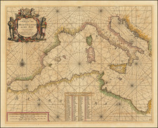
Finely colored, gold heightened example of Pieter Goos's sea chart of the Eastern Mediterranean.
Decorative sea chart of the Eastern Mediterranean. With Sicily, Malta, Crete and Cyprus, from Goos's De Zee-Atlas, Ofte Water-Weereld, Waer in vertoont werden alle de Zee-Kusten Van het bekende des Aerd-Bodems, published in Amsterdam.
Pieter Goos' marine atlases were held to be among the finest printed at the time and were often added to the nine or twelve volumes of Blaeu's Atlas Maior. (R. Shirley)
Pieter Goos (ca. 1616-1675) was a Dutch map and chart maker, whose father, Abraham Goos (approx. 1590-1643), had already published numerous globes, land and sea maps together with Jodocus Hondius and Johannes Janssonius in Antwerp. Pieter gained recognition due to the publication of sea charts. He bought the copperplates of the famous guide book for sailors, De Lichtende Columne ofte Zeespiegel (Amsterdam 1644, 1649, 1650), from Anthonie Jacobsz. Goos published his own editions of this work in various languages, while adding his own maps. In 1666, he published his De Zee-Atlas ofte Water-Wereld, which is considered one of the best sea atlases of its time. Goos' sea charts came to dominate the Dutch market until the 1670s, when the Van Keulen family came to prominence.
![[Hand-Drawn Map Showing the Extent of the Ottoman Empire]](https://storage.googleapis.com/raremaps/img/small/99654.jpg)
![[Composite Lafreri-style Atlas of Battle Plans and Fortifications]](https://storage.googleapis.com/raremaps/img/small/92702.jpg)
![(Sea Atlas of the Mediterranean) ['t Nieuw Groot Straets-Boeck Inhoudende de Middellandtsche Zee . . .] Nieuwe Water-Werelt, ofte Zee-Atlas. Verthoonende Alle gelegentheden der Zee-Custen. . .](https://storage.googleapis.com/raremaps/img/small/92441.jpg)
![[ Italian Mediterranean Coastline ] Hydrographica descriptio, in qua ore maritime Italiae a monte Argentato Napolim usque, promontoria item & portus, ajacentes insule...](https://storage.googleapis.com/raremaps/img/small/97984.jpg)