|
||

|

|
|

|
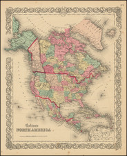
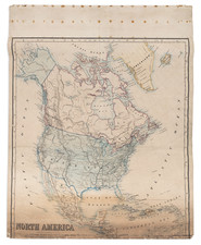
Rare decorative map of North America, published jointly by Maggi in Torino and Stucchi in Milan. The map is largely reminiscent of the Fredonia map by R.H. Laurie and contemporary French maps by Brue and Lapie. Provides a fine depiction of the travels of Lewis & Clark, Pike, Humboldt and Long. One of the mythical rivers of the West extends to Lake Timanagos, but the second river is truncated in a range of mountains extending from the Bay area to just south of the lower (mythical) Salt Lake. Galveston and the Presidio appear in Province of Texas, among other places. Excellent detail east of Salt Lake. Ft. Mandan and Ft. Mannel are shown on the upper Missouri, and many of the Hudson Bay Trading Houses are shown, including Chesterfield, Nelson, Acton, Buckingham, Hudson, Carlton, Cigna, Albany, Grent, Pine, Brandon, and others, a few of which are unnamed. Arkansas is double wide. Many forts and Indian Tribes named in the West and Mississippi and Missouri River Valleys. The Missions of California are all named. Remarkable crisp engraving style, with a decorative cartouche. The reference to Colombia is highly unusual, perhaps the only 19th Century map we know of to use this name. The map is apparently unrecorded. A gorgeous wide margined example A gorgeous wide margined example, which was apparently sheet No. 5 in Stucchi's Grande Atlante universale. We have noted another copy dated 1825, which was offered in a dealer catalogue in 1992.