![[ Cygnus ] By Johann Bayer](https://storage.googleapis.com/raremaps/img/small/83197.jpg)


|
||

|

|
|

|
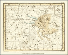
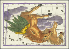
Fine example of Bayer's map of the Constellation Cygnus, one of the 48 constellations listed by the 2nd-century astronomer Ptolemy, which remains one of the 88 modern constellations defined by the International Astronomical Union.
Cygnus is a Latinized version of the Greek word for the swan.
The plate was originally included in the forty-eight maps of the individual constellations in Bayer's Uranometria, in 1603. This is from the first reissue, without text on verso. The stars are identified by letters, Greek for the brightest, Roman for the fainter, with the order of the alphabets corresponding to decreasing brightness of the stars. Although a similar scheme had been introduced by Piccolomini (1540), it was Bayer's scheme that became universally accepted. Bayer based his constellation figures on the work of Jacobo de Gheyn and included stars from Ptolemy as well as the recent observations of Tycho Brahe and Keyser.
Bayer's Uranometria is one of the most important celestial atlases of the 17th century and the first modern star atlas. The atlas contained fifty-one star-charts, including forty-eight charts of the Ptolemaic constellations and two charts of the hemispheres. Bayer's constellation figures are based on the work of Jacobo de Gheyn.
The work was important for a number of reasons. Bayer introduced a new system of stellar nomenclature which used Greek and Roman letters to denote relative brightness in each constellation. In this system, the brightest stars were denoted with Greek letters, and the dimmest stars given Roman lettering. The resulting names persist to the present day (replacing Piccolomini's 1540 naming convention) and were of great help in standardizing the practice of astronomy. These letters were placed on the charts themselves, and also in a table that accompanied each chart. To provide an example of the system at work, the name of the brightest star in the constellation Taurus is now known as Alpha Tauri, with the second brightest star being Beta Tauri, and so forth. Further innovations in this work include each plate having a carefully engraved grid, so that star positions can be read off to fractions of a degree. These positions were taken from the catalog of Tycho Brahe's circulated manuscript prior to its 1602 publication. The Uranometria was also the first atlas to represent the stars of the southern latitudes as discovered to Europeans during Houtman's voyage to the East Indies in 1595.
Bayer's charts would be recognized as one of the four great celestial atlases. Almost all later atlases, including Bevis's, would be based heavily on his work. In addition, some scholars believe that the Uranometria influenced the works of scientists like Schiller and Kepler. In all, these are scientifically important and artistically stunning works, Bayer's charts are rarely offered separately on the market.
Alexander Mair , son of William Mair and his wife Catherine, born Garland, was a sworn land surveyor in Natal.
In 1869 he compiled a "General plan of Vaal Kop and Dadel Fontein", which included several farms with the names of their owners. By 1870 he was city surveyor of Pietermaritzburg.
In 1875 he compiled the first topo-cadastral map of Natal, which was one of the best maps of that territory to appear before the turn of the century. It was based on property maps in the surveyor-general's office. This Map of the Colony of Natal, on a scale of 4 miles to the inch (1:253 440), was printed in London on four sheets. It had relief sketched in, but contained no contours. All the farms in the colony were shown, with their names. It would appear that Mair was acting surveyor-general of Natal at the time, in the absence of P.C. Sutherland*.
Though Mair was listed as absent from Natal in 1880, he later returned and in September 1885 took over the secondary triangulation of the territory from H.D. Laffan*, who returned to the geodetic survey of the Cape Colony.
Mair carried a triangulation into Zululand across the Tugela River as far as Melmoth. His triangulation stations near that town served as basis for the boundary survey carried out by Major McKean at the end of 1886. During 1887-1888 Mair worked mainly in the Umvoti region and the next year wrote a progress report on the survey of Zululand. He was still listed as a land surveyor in Natal in 1890.
He was married to Eliza Adelaide, born Varty (or Varlip), with whom he had a son and a daughter.