


|
||

|

|
|

|
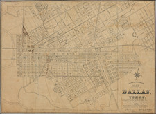
Rare large format guide map of Dallas, with a large inset of the downtown region at the bottom and key on the verso.
Identifies Street Car Lines, Railroads, the 1922 City Limits, Piked Roads and Street Numbering. The promotional text on the cover shows statistical information up to 1924.
Shows the names of a number of early subdivisions, including Junius Heights, Mt. Auburn, Munger Place, Parkview, Lakewood, Belmont, Vickery, Highland Park West, Highland Park, Oak Lawn, and University Park on the East side of the Trinity River and Oak Cliff, West Dallas, Trinity Heights, Sunset and Kessler Square on the West side. A key at right of hte map identifies approximately 20 buildings in the downtown area.
This map was updated on a regular basis and is a remarkable way to track the growth of Dallas in the 1920s.
![[ Texas - Dallas to El Paso ] Flight Chart- Dallas Fort Worth to El Paso, U.S.A.](https://storage.googleapis.com/raremaps/img/small/98371.jpg)

![[Restricted] New Orleans (0-6)](https://storage.googleapis.com/raremaps/img/small/68648.jpg)