This item has been sold, but you can enter your email address to be notified if another example becomes available.


|
||

|

|
|

|
Stock# 83694
Description
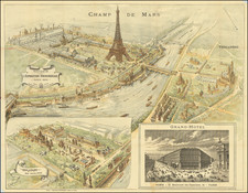
Very nice early 20th-century tourist map of Paris, focusing on its major buildings, monuments, and other tourist attractions.
The map is particularly impressive for its pictorial qualities, with every major monument in Paris displayed. Not only are the Eiffel Tour, Notre Dame, Trocadero, and Arc de Triomphe shown, but also many of the more minor monuments like the Invalides, Madeleine, and Opera. The city proper is shaded red, with walls demarked on the outside, while suburbs, including Neuilly, are shown in green.
The lines of the Paris Metro are shown in red, with the North-South Train Line shown in blue. Major railroads out of the city are shown in black.
Condition Description
Folding map, with original cover reading "Paris Monumental Metropolitain Prix 2F50 Price 2 SH." Nice dark image. Minor red staining to left of map. One or two extraneous folds, with one small hole at an intersecting fold.

![[ Downtown St. Helena ] Mattioli's in your Pocket Guide St. Helena -- 13th Annual Edition [ Napa Valley, CA ]](https://storage.googleapis.com/raremaps/img/small/102768.jpg)