This item has been sold, but you can enter your email address to be notified if another example becomes available.


|
||

|

|
|

|
Stock# 83685
Description
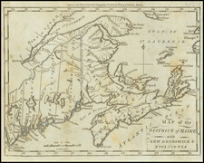
War of 1812 Chart of Maine / Penobscot Bay - Mount Desert Island - Bangor
Fine example of John Luffman's rare chart of the area around Penobscot Bay to Mount Desert Island and Bangor, drawn from British naval sources during the War of 1812.
The text at the bottom notes:
Penobscot River and Bay, A fine port of North America in the United States situated in the Province of Maine. It was taken with all the neighboring settlements, by British Forces, under Lieutt. Genl. Sr. I.C. Sherbrook, K.B & Rear Adml Griffith, 1814 . . .
Rarity
Maps by John Luffman are very scarce on the market, this being the first time we have had this one.
![[ The Finest Colonial New England Sea Chart of the 18th Century ] The Coast of New England](https://storage.googleapis.com/raremaps/img/small/63672.jpg)