|
||

|

|
|

|
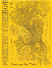
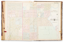
Interesting real estate map of Fairhaven, Washington, an outlying community of Bellingham, close to the border with Canada. The map was produced by Edmund S. Hincks, a local draughtsman.
The map appears to have been produced to promote the services (and, perhaps, land holdings) of "Gamwell & Warner, Investment Bankers, Fairhaven, Washington", which is overprinted on the upper-right corner of the map.
The map depicts the lines of the Great Northern Railroad, the Canada Pacific Railroad, and the Fairhaven and New Whatcom Electric Railway.
The map shows the Fairhaven Hotel, which was built in 1890, and clearly depicts the city before its merger with Bellingham and three other communities in 1903.
On the left side of the map are insets of "Map of Bellingham Bay, Whatcom Co., Wash." and "Map of Western Washington, showing location of Whatcom County".
The map is redolent of Whitney's maps of cities in Washington and Oregon, which were done around the same time for the Union Pacific, however, it makes no mention of the railroad nor of Whitney. Hincks did make a map of Bellingham in concert with Whitney, for the Union Pacific.
Fairhaven: From "Dirty Dan" to Bellingham
The original blueprint for Fairhaven was laid down on January 2, 1883, by the eccentric and intriguing figure, Daniel J. Harris.
Daniel Jefferson Harris, better known as "Dirty Dan", first set foot in the Bellingham Bay area between 1853 and 1854. Establishing early ties, he collaborated with John Thomas, who had already claimed a piece of land along Padden Creek. Together, they began constructing a cabin. However, tragedy struck when Thomas died, leaving the cabin incomplete. Seizing the opportunity, Harris finalized the land claim, with the patent being officially issued in 1871. Over time, Harris expanded his acquisitions, and the area was christened Fairhaven, inspired by the native term "see-see-lich-em," meaning "safe port" or "fair haven." Some believe the name might have also been influenced by a town in Maine, speculated to be Harris' birthplace. By 1883, Harris had plotted out the town and began trading plots.
However, in 1888, a significant transition occurred. Harris sold a majority of his Fairhaven assets to Nelson Bennett and ventured off to California. Bennett, teaming up with Charles Larrabee who arrived in 1890, set up the Fairhaven Land Company, primarily financed by Larrabee. The duo was determined to elevate Fairhaven's status. They projected an image of a land abundant in resources, promising opportunities, and a climate of growth. This advertising gambit worked, and by the close of 1890, the population ballooned from a mere 150 in 1889 to an impressive 8,000. This growth was also catalyzed by the Fairhaven Land Company's acquisition of a neighboring settlement, Bellingham.
Amidst this whirlwind of development in the late 1870s to mid-1880s, Fairhaven, like many coastal cities in Washington, was in the race to become the terminal city for the Great Northern Railroad. Though Seattle was eventually chosen, the city's continued to grow and on May 13, 1890, Fairhaven was officially incorporated.
However, the town's rapid ascent was soon met with a steep decline. In the years 1890-1892, buildings sprouted in abundance, only to be abruptly halted by the devastating economic depression of 1893. The dawn of the 20th century brought with it a phase of gradual growth, culminating in Fairhaven's union with the neighboring town of Whatcom in 1903, to form the town of Bellingham.
Rarity
The map is extremely rare.
OCLC locates copies at Washington State University, Yale University and Wisconsin Historical Society Library and Archives.
![Pacific Coast Highways Canada to Mexico [Texaco Tour Maps Routes and Mileages Canada to Mexico]](https://storage.googleapis.com/raremaps/img/small/91594.jpg)