


|
||

|

|
|

|
Stock# 83528
Description
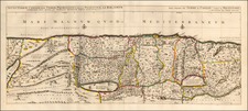
Detailed early map of the Holy Land, oriented with east at the top.
The map shows the divisions of the eleven tribes as well as 43 Israelite desert encampments represented by tents. The western shoreline goes from Beirut in the north to the Nile Delta in the south. The Kishon River, here called Chedumin flu, connects Haifa Bay and Tiberius Lake (the Sea of Galilee). Five cities appear in the Dead Sea; Sodoma, Gomora, Adamo, Seboim and Segor. There are many place names and cities shown, with several in Hebrew.
The map was re-issued on a number of occasions, this being the first edition.
![[Tribe of Judah] Tribus Iuda id est, pars illa Terra Sanctae quam in ingressu Tribus Iuda confecuta fuit](https://storage.googleapis.com/raremaps/img/small/82548.jpg)
![[Tel Aviv - Yafo] A View of the City and Port of Joppa at Present Called Jaffa. According to our modern Travellers](https://storage.googleapis.com/raremaps/img/small/89073.jpg)

![[ Holy Land ] Das Heilig Landt mit außtheilung der zwölff Geschlechter](https://storage.googleapis.com/raremaps/img/small/100589.jpg)