|
||

|

|
|

|
Stock# 83490
Description
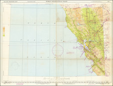
Detailed topographical map of Southwest Riverside County, published by the US Geological Survey.
The map extends north to Riverside and San Timoteo Canyon and is centered on the Perris, Lake Elsinore Area, extending south the the San Diego County border and Temecula.
The map focuses on the topography of the region, but also includes roads, railroads, rivers, towns, mountains and other early details, including the location of early structures.


![[ Cabo San Lucas, Southern Baja ] Delineatio Nova Et Vera Partis Australis Novi Mexici, cum Australi Parte Insulae Californiae Saeculo Priori ab Hispnis Detectae.](https://storage.googleapis.com/raremaps/img/small/95666.jpg)