


|
||

|

|
|

|
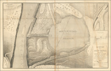
Very interesting antique map showing the results of the Coppermine Expedition of 1819-1822, lead by Captain John Franklin and tasked with mapping the great rivers of northern Canada. The shows the route taken by Franklin and his explorers during the years 1820 and 1821, as they made their to the north Arctic coastline. This map was published in 1823 in Philadelphia as part of a report on the expedition entitled Narrative of a Journey to the Shores of the Polar Sea.
The map shows the route undertaken by the explorers as they started at the Great Slave Lake and headed up the Yellow Knife River. From there, they portaged over to the Coppermine River, which they descended. They tracked the Arctic Coastline along a "Gravelly Beach" for over a hundred miles before returning south along Bathurst Inlet.
The expedition was considered a success for its mapping of the northern coast of Canada, but it was a failure in terms of planning. Half of the party died due to malnourishment, and the expedition had to be rescued by members of the Yellowknives Nation.
![Carta rappresentante una parte della Baja Hudson, e le Regioni a Maestro dell'America Settentrle. [Map representing a part of Hudson Bay, and the regions to the northwest of North America.]](https://storage.googleapis.com/raremaps/img/small/95989.jpg)
![(Inuit Self Portrait) [Original watercolor of George Niagungitok] George Niakungitok, Esquimaux, Indian, price 6d, Drawn by Himself [mounted in:] The White Peninsula, A Journey in Russian Lapland and Karelia by Edward Rae.](https://storage.googleapis.com/raremaps/img/small/94266.jpg)
![[ Polar Regions ] Pais qui Dependent de la Norvege Suivant les Derniers Relations Par N. de Fer.](https://storage.googleapis.com/raremaps/img/small/100688.jpg)
![(Photograph album) America | Hawaii. 1885. [Photographic album of Hawaii, Yellowstone, Utah, Colorado, and Niagara Falls]](https://storage.googleapis.com/raremaps/img/small/87949.jpg)