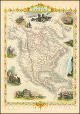
![[ Separately Published with Early Hand Drawn Addition of the Le Maire Strait ] Americae Sive Novi Orbis Nova Descriptio By Abraham Ortelius](https://storage.googleapis.com/raremaps/img/small/94478.jpg)


|
||

|

|
|

|
Rare First State of Abraham Ortelius' Map of the Americas, One of the Most Iconic Maps of the Western Hemisphere
Fine old-color example of the first state of Ortelius' map of the Americas, with the erroneous inclusion of the Canariae insule at the top left, rather than the Azores.
It is estimated that only roughly one hundred copies of this first state of the map were printed, before the error was corrected for the second printing. The map went through three plates overall, making three distinct editions of the map. Additionally, there are several states of the first and third editions. This is one of the rarest states available and is seldom seen on the market.
The map, which shows both North and South America, featured in Abraham Ortelius' influential Theatrum Orbis Terrarum, the first modern atlas of the world. It is the “first depiction of the Americas in a regular atlas” and of “fundamental importance,” according to Van Den Broecke. Ortelius' Americae Sive Novi Orbis Nova Descriptio is without a doubt one of the most recognized and influential maps of the Americas from the sixteenth century and it had a profound influence on contemporary cartography.
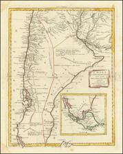
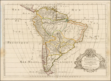
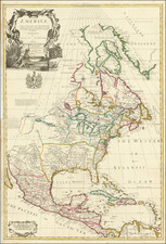
North and South America stretch across the map. To the north, North America resembles the continent we know today, except that the area near Alaska is undefined and the Pacific Northwest bulges to the west. South America is a squat landmass, with early editions having an extension in the southwest that would disappear in the third edition of the map.
Ortelius' ability to locate and draw upon both Spanish and Portuguese sources is apparent throughout the map; this is quite remarkable given the manner in which each nation guarded its cartographic information. The overall shape of the continents is derived from Mercator’s 1569 world map. Mercator and Ortelius were friends and they shared information readily with each other.
The title is decorated with the fine strapwork decorations common to the maps in Ortelius' atlas. In the ocean, a sea monster lurks. In the Pacific, small ships stream through the water, their sails filled with imaginary winds.
One much larger ship catches the wind just northeast of New Guinea, which is shown as a large landmass. The name "Novae Guinea", or New Guinea, was coined by Spanish explorer Íñigo Ortíz de Retes in 1545, and it refers to his opinion that the appearance of the native peoples resembled the natives of the Guinea region of Africa.
The Strait of Magellan separates South America from a large southern continent that extends all the way to New Guinea, although the cartouche obscures part of the shores. Tierra del Fuego, named by Magellan because he saw so many small fires burning there, is part of this continent.
Two place names in the northwest of North America are particularly interesting. Anian derives from Ania, a Chinese province on a large gulf mentioned in Marco Polo's travels (ch. 5, book 3). The gulf Polo described was actually the Gulf of Tonkin, but the province's description was transposed from Vietnam to the northwest coast of North America. The first map to do this was Giacomo Gastaldi's world map of 1562, followed by Zaltieri and Mercator in 1567. The Strait then became shorthand for a passage to China, i.e. a Northwest Passage. It appeared on maps until the mid-eighteenth century.
Quivira refers to the Seven Cities of Gold sought by the Spanish explorer Francisco Vasquez de Coronado in 1541. In 1539, Coronado wandered over what today is Arizona and New Mexico, eventually heading to what is now Kansas to find the supposedly rich city of Quivira. Although he never found the cities or the gold, the name stuck on maps of southwest North America, wandering from east to west.
Ortelius' atlas and the states of Americae Sive Novi Orbis
The influence of this and other Ortelius maps stems from the popularity and dominance of his atlas in the European market. In 1570, Ortelius published the first modern atlas; that is, a set of uniform maps with supporting text gathered in book form. Previously, there were other bound map collections, specifically the Italian Lafreri atlases, but these were sets of maps—they were not necessarily uniform and were bound together on demand.
Theatrum Orbis Terrarum, Ortelius's atlas, was initially published in May of 1570 and was an instant success; there were four editions in the first year alone. It outperformed competing atlases from other cartographic luminaries like the Mercator family. Between 1570 and 1612, 31 editions of the atlas were published in seven languages. This map, in its first edition, appeared in the very first 1570 atlas.
The plate was replaced twice, for a total of three plates creating three editions. The second plate was engraved in 1579; the large ship in the Pacific reverses direction and the cartouche has different figures. This second state was included in the first editions of the atlas printed by the famous printing house of Christopher Plantin.
In 1587, the third plate was made, this time to reduce the bulge on South America’s west coast and to add details in the islands of the Pacific. This third state includes the Solomon Islands, as well as Cape Mendocino and California as toponyms. On the east coast of North America the name Wingandekoa refers to the English attempt to colonize the Outer Banks. From 1600 the atlas was published by Jan Baptist Vrients. In 1612, the plates passed to Jan and Balthasar Moretus, heirs of the Plantin press.
There were also several states of each edition, except the second, of which no extra states are known by Van den Broecke. The first edition has the following states:
State 1: The Azores are mislabeled as the Canarie insule. 1570.
State 2: The Azores are correctly named. 1570.
State 3: The plate cracked in the upper left and was reworked. This fix erased the longitude number 230 at the top. 1575.
The third edition has the following states:
State 1: Included in all issues to 1612.
State 2: Addition of Fretum le Maire. 1628.
Interestingly, Van Den Broecke reports a suspected fourth plate that was not printed widely at the time.
Rarity
The first state of the map is exceptionally rare, especially in old color.
We previously offered this example for sale in 2012.
Abraham Ortelius is perhaps the best known and most frequently collected of all sixteenth-century mapmakers. Ortelius started his career as a map colorist. In 1547 he entered the Antwerp guild of St Luke as afsetter van Karten. His early career was as a business man, and most of his journeys before 1560, were for commercial purposes. In 1560, while traveling with Gerard Mercator to Trier, Lorraine, and Poitiers, he seems to have been attracted, largely by Mercator’s influence, towards a career as a scientific geographer. From that point forward, he devoted himself to the compilation of his Theatrum Orbis Terrarum (Theatre of the World), which would become the first modern atlas.
In 1564 he completed his “mappemonde", an eight-sheet map of the world. The only extant copy of this great map is in the library of the University of Basel. Ortelius also published a map of Egypt in 1565, a plan of Brittenburg Castle on the coast of the Netherlands, and a map of Asia, prior to 1570.
On May 20, 1570, Ortelius’ Theatrum Orbis Terrarum first appeared in an edition of 70 maps. By the time of his death in 1598, a total of 25 editions were published including editions in Latin, Italian, German, French, and Dutch. Later editions would also be issued in Spanish and English by Ortelius’ successors, Vrients and Plantin, the former adding a number of maps to the atlas, the final edition of which was issued in 1612. Most of the maps in Ortelius' Theatrum were drawn from the works of a number of other mapmakers from around the world; a list of 87 authors is given by Ortelius himself
In 1573, Ortelius published seventeen supplementary maps under the title of Additamentum Theatri Orbis Terrarum. In 1575 he was appointed geographer to the king of Spain, Philip II, on the recommendation of Arias Montanus, who vouched for his orthodoxy (his family, as early as 1535, had fallen under suspicion of Protestantism). In 1578 he laid the basis of a critical treatment of ancient geography with his Synonymia geographica (issued by the Plantin press at Antwerp and republished as Thesaurus geographicus in 1596). In 1584 he issued his Nomenclator Ptolemaicus, a Parergon (a series of maps illustrating ancient history, sacred and secular). Late in life, he also aided Welser in his edition of the Peutinger Table (1598).