|
||

|

|
|

|
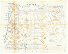
Lands Granted to the Oregon & California Railroad
Rare separately published map of northwestern Oregon, printed by Rand McNally & Co. for the Oregon & California Railroad Company.
The map covers most of Douglass, Josephine and Jackson Counties, illustrating the thirty and twenty mile limit for the Oregon and California Railroad grant.
This map covers the southwestern corner of Oregon, west of Klamath Lake and south from Bandon, just below Coos Bay. Four bands of color show the limits of the grants to the Oregon & California Railroad to sell lands.
This appears to have been one of a set of three maps of company lands in Oregon, all very rare.
The Oregon & California Railroad Company
The Oregon and California Railroad was formed from the Oregon Central Railroad. The Oregon Central Rail Road was the name of two railroad companies, each of which claimed federal land grants that had been assigned to the state of Oregon in 1866 to assist in building a line from Portland south into California. The "East Side Company" of Salem (incorporated 1867), supported by businessman Ben Holladay, eventually received the grant for its line east of the Willamette River, and was reorganized in 1870 as the Oregon and California Railroad (O&C), which completed the line in 1887. The City of Portland supported the competing "West Side Company" (incorporated 1866), which only built to McMinnville, and was sold to the O&C in 1880.
In 1887, the line was completed over Siskiyou Summit and the Southern Pacific Railroad assumed control of the railroad. However, it was not officially sold to Southern Pacific until January 3, 1927.
Rarity
Rand McNally & Co. is a large American map and navigation company best known for its annual atlases. The company got its start in 1856, when William Rand opened a print shop in Chicago. He was joined in 1858 by a new employee, Andrew McNally. Together, the men established their namesake company in 1868. Originally, the company was intended to print the tickets and timetables for the trains running to and through Chicago; their first railway guide was published in 1869.
By 1870, they had shifted from just printing to publishing directories, travel guides, and newspapers. Their first map appeared in 1872 in a railway guide. The map was produced using a new wax engraving method, a cheaper process that gave the company an edge.
By 1880 Rand McNally had entered the education market with globes, wall maps, and geography texts for students. In 1923, Rand McNally published the first Goode’s World Atlas, named after its editor, Dr. J. Paul Goode. For generations afterward, this would be the standard classroom atlas.
In 1899, William Rand left the company, but McNally and his family remained, controlling the company for over a century. In 1904, they published their first road map intended for automobiles and by 1907 were publishing Photo-Auto Guides, which combined photography and mapping to help drivers. In 1924, they produced the Auto Chum, a precursor to their famous road atlases. Rand McNally would remain the leader in road maps and atlases throughout the twentieth century.
In 1937, Rand McNally opened its first store in New York City. Ever on the frontier of technology, Rand McNally pioneered the scribing process for printing tickets in 1958 and printed their first full-color road atlas in 1960. Arthur Robinson developed his now-famous projection of Rand McNally in 1969. By the 1980s, the company was exploring digital reproduction and digital databases of maps for truckers. In the 1990s, they lead the charge to develop trip-planning software and websites. Today, most of its products are available online or in a digital format, including maps for tablets and phones.
![[Report and] Map of an Exploring Expedition to The Rocky Mountains in the Years 1842 and to Oregon & North California in the Years 1843-44 By Brevet Capt. J. C. Fremont of the Corps of Topographical Engineers . . .](https://storage.googleapis.com/raremaps/img/small/88488.jpg)