


|
||

|

|
|

|
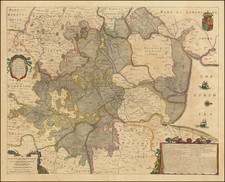
The Fens Before They Were Drained
Nice old color example of the Hondius/Jansson map of the fens of East Anglia. The map, with north orientated to the right, shows the region between Cambridge and the North Sea, including Ely, Cambridge, and Peterborough.
The map shows the fens, then still flooded, with Ely acting as its own island. Many small villages are named, and, southwest of Swaffham Prior, a strange torch stands at the top of a hill. Part of Lincolnshire is named Holland, which reflects the regions close ties to the Low Countries. The map includes the royal coats of arms and three cartouches, including one that lists important governmental figures from the region.
This map shows the fens before they were fully drained, with the significant drainages having occurred in the 1630s. In order to reclaim large amounts of land for agricultural purposes, a series of royal commissions attempted to remove all the water from the area using a system of dikes and pumps. Locals were opposed to this, as a large part of the economy was built around fishing and hunting, which the fens were perfect for. Draining the fens took until the 19th century, when modern steam engines proved finally powerful enough to fully pump water from out of the region.
This map represents a later state of a map of the same name first published by Henricus Hondius sometime around 1632. Hondius published a series of maps of the British regions, which were based on the most accurate sources at the time.
Jan Janssonius (also known as Johann or Jan Jansson or Janszoon) (1588-1664) was a renowned geographer and publisher of the seventeenth century, when the Dutch dominated map publishing in Europe. Born in Arnhem, Jan was first exposed to the trade via his father, who was also a bookseller and publisher. In 1612, Jan married the daughter of Jodocus Hondius, who was also a prominent mapmaker and seller. Jonssonius’ first maps date from 1616.
In the 1630s, Janssonius worked with his brother-in-law, Henricus Hondius. Their most successful venture was to reissue the Mercator-Hondius atlas. Jodocus Hondius had acquired the plates to the Mercator atlas, first published in 1595, and added 36 additional maps. After Hondius died in 1612, Henricus took over publication; Janssonius joined the venture in 1633. Eventually, the atlas was renamed the Atlas Novus and then the Atlas Major, by which time it had expanded to eleven volumes. Janssonius is also well known for his volume of English county maps, published in 1646.
Janssonius died in Amsterdam in 1664. His son-in-law, Johannes van Waesbergen, took over his business. Eventually, many of Janssonius’ plates were sold to Gerard Valck and Pieter Schenk, who added their names and continued to reissue the maps.
![[Hungarian Map of Great Britain] Nagy Britannia](https://storage.googleapis.com/raremaps/img/small/85219.jpg)
![[ Roman Roads of the Antonine Itinerary ] In gratiam Itinerantium Curiosorum Antonini Aug Itinerarium per Britanniam, tentavit W. Stuckeley 1723](https://storage.googleapis.com/raremaps/img/small/103265.jpg)
![[England, Scotland & Wales]. Parte Settentrionale del Regno d'Inghilterra . . . (with) Parte Meridionale del Regno d'Inghilterra . . .](https://storage.googleapis.com/raremaps/img/small/89516.jpg)