|
||

|

|
|

|
Stock# 8343
Description
Detailed map of the 3 counties, hand colored by townships. Shows towns, roads, rivers, mountains, lakes, railroads, post offices and other early information. Includes a scale of miles. From Walling & Gray's New Topographical Atlas of the State of Pennsylvania, perhaps the most popular of all 19th Century Atlases of the State.
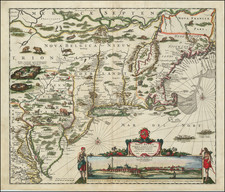
![[ Inhabitants of New Netherlands ] Einwohner in Neu Niederland](https://storage.googleapis.com/raremaps/img/small/94087.jpg)