|
||

|

|
|

|
Stock# 83422
Description
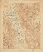
Detailed topographical map of Eastern San Diego County, extending from The Cuyamacas and San Vincente Valley to Otay and the border, published by the US Geological Survey.
The map focuses on the topography of the region, but also includes roads, railroads, rivers, towns, mountains and other early details, including the location of early structures.
![[ Pacific Coast Pictorial Road Maps ] Scenic Touring Scout](https://storage.googleapis.com/raremaps/img/small/101745.jpg)