This item has been sold, but you can enter your email address to be notified if another example becomes available.


|
||

|

|
|

|
Stock# 83421
Description
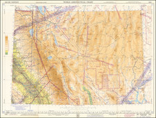
Detailed topographical map of Northeast San Diego County, extending from the Sweetwater River to San Vicente, centered on the San Diego River and El Cajon Valley, published by the US Geological Survey.
The map focuses on the topography of the region, but also includes roads, railroads, rivers, towns, mountains and other early details, including the location of early structures.
![[The 5 Californias] Carte de la Californie Suivant 1. La Carte manuscrite de l'Amerique de Mathieu Neron Pecci olen dressee a Florence en 1604, 2. Sanson 1656 . . .](https://storage.googleapis.com/raremaps/img/small/97983.jpg)
![(San Diego Photograph) [Large bird's-eye photograph of downtown San Diego, with the Hotel del Coronado and Point Loma in the distance]](https://storage.googleapis.com/raremaps/img/small/94504.jpg)