|
||

|

|
|

|
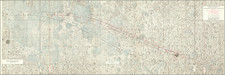
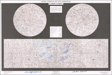
How to Get One's Bearing on the Moon.
Detailed photographic map of the Hadley-Apennine Site, the landing area for Apollo 15, the fourth manned mission to land on the Moon, and the first to use the Lunar Roving Vehicle.
The landing site is marked on the map with a central circle titled "Horizon" with an "LM" at the center.
There is an interesting mapping convention deployed in this map: the topography is shown photographically and highlighted with contour lines, which themselves correspond to landscape views on each of the four sides of the map. Presumably, this was intended to help the astronauts get and keep their bearings upon landing on the moon. That approach to mapping is similar to the integral coastal profiles of early sea charts.
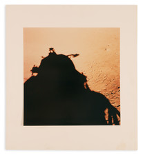
An object shown rising over the eastern mountains in the profile at far-right must be the sun.