
This item has been sold, but you can enter your email address to be notified if another example becomes available.


|
||

|

|
|

|
Stock# 83351
Description
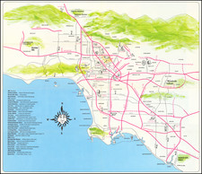
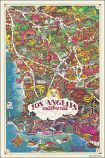
Centered on Watts, with Port Los Angeles North of Santa Monica!
Fine detailed map of Los Angeles, with an unusual birdseye view style transit map on verso, showing the Los Angeles Basin, with a detailed early map of Los Angeles on the verso.
One of the more curious features is the location of "Port Los Angeles" north of Santa Monica!
Primary Rail lines include:
- Southern Pacific RR
- Santa Fe RR
- Pacific Electric RR
- L.A. Pacific RR
- LA Interurban RR
The map extends south to Newport and Huntington Beach, east to Chino, Pomona and Lordsburg and North to Burbank, Verdugo, Altadena and Monrovia.
The vignettes showing small trains on the tracks is quite unusual.
Rarity
The map is rare. This is the second example we have ever seen.
Condition Description
Original printed covers.
![[ Norma Triangle / West Hollywood / Sunset Strip / Santa Monica Blvd ] Map of West Knoll Los Angeles County, California](https://storage.googleapis.com/raremaps/img/small/97769.jpg)
![[ Southern California Tourism ] Hunting and Fishing in Southern California on the Santa Fe](https://storage.googleapis.com/raremaps/img/small/101613.jpg)
![[Hollywood / Los Angeles] Castle's Inc. Hollywood's Complete Camera Store](https://storage.googleapis.com/raremaps/img/small/73017.jpg)