


|
||

|

|
|

|
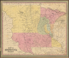
Mapping America's Second Transcontinental Railroad
Fine large promotional map for the Northern Pacific Railroad, published 3 years after its completion across the continent in 1883.
The main line of the Northern Paific is shown in red, including dozens of stations between Minneapolis, Ashland and Duluth (the New Chicago) in the east and Tacoma and Portland in the west. Several other feeder lines are shown in red in Montana, servicing the mining boom towns of southwestern Montana, along with a proposed route to Fort Benton. Several feeder lines are also shown in the Dakotas.
In Oregon and Washington, several local lines are shown in black most notably the Oregon Railway and the Oregon & California.
The line of the Oregon Railway & Navigation Company between Portland and Pasco, Oregon is also noted.
On the verso is promotional text, mostly appealing to tourists and propsective migrants, along with time tables and other information. The New Line to Butte City is referenced, along with Dining Cars in Montana Territory, Pullman Sleepers and, of course, access to Yellowstone National Park via Cinnabar.
The map is impressively detailed, including early roads, towns, topographical features, etc.
Rarity
The map is quite rare on the market.
We note that it was first issued in about 1884, with periodic updates, perhaps as often as on a monthly basis, in 1885, 1886, 1887,1888 and 1889
With the exception of the UC Berkeley/Bancroft Library, which holds about 6 examples, the map is exceedingly rare.
We were unable to locate other examples in reported auctions or in dealer records.

![[Esparto, California] Map Showing Subdivisions of the Bonynge Tract and the Position of the Townsite of Esperanza Yolo County California... 1887-1888](https://storage.googleapis.com/raremaps/img/small/83457.jpg)
![[California Road Atlas] Easy Fold Maps of California Highways](https://storage.googleapis.com/raremaps/img/small/73977.jpg)
![(California-Mexico Border Survey) Datos de los trabajos astronómicos y topográficos. [bound with:] Variedades de la civilizacion, nueva epoca (Tomo I)](https://storage.googleapis.com/raremaps/img/small/70777.jpg)
![(California - 19th-Century Photographs) [Album of 33 photographs of California, Oregon, and Washington, including Yosemite Valley, Stanford University, Sutro Heights in San Francisco; Mt. Hood; Mt. St. Helens; Portland, Oregon]](https://storage.googleapis.com/raremaps/img/small/94083.jpg)