|
||

|

|
|

|
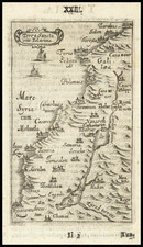
Rare separately published map of the Holy Land, "From Burkhardt, Mangles, &c." and crediting noted British mapmaker John Walker as the compiler of the map.
The map is meticulously compiled, with the topographical features and finely executed color characteristic of Walker's work.
The credit to Burckhardt, Mangles &c. references two contemporary explorers who wrote extensively about the region in the decade before the publication of the map.
Johann Ludwig Burckhardt (also known as John Lewis, Jean Louis) (1784 – 1817) was a Swiss traveler, geographer and Orientalist. Burckhardt used the name Sheikh Ibrahim Ibn Abdallah during his travels in Arabia. He is best known for rediscovering the ruins of the ancient Nabataean city of Petra in Jordan. Burckhardt undertook an immersive study of regional culture during the last 8 years of his life, traveling expansively in Palestine and contiguous regions posing as a poor Arab man.
James Mangles FRS FRGS (1786 – 1867) was an officer of the Royal Navy, naturalist, horticulturalist and writer. He served during the French Revolutionary and Napoleonic Wars, rising to the rank of captain. In 1816, Mangles and Captain Charles Leonard Irby undertook a lengthy tour in Europe, Egypt, Syria, and Asia Minor, visiting Egypt, traveling up the Nile River with Giovanni Baptista Belzoni and Henry William Beechey, and visiting the temple at Abu-Simbel. The party next crossed the desert to Baalbek and the cedars, before traveling to Aleppo, where they met William John Bankes and Thomas Legh. As a group, they made an extensive tour of Syria, including Almyra, Damascus, down the Jordan valley, to Jerusalem. Later they rounded the Dead Sea, explored Palestine. They ended their tour in Europe bound for Constantinople; but were forced to abandon the trip in Cyprus in December 18181.
Rarity
The map is extremely rare. There are no auction or dealer catalog records.
OCLC locates 3 examples, none in American Institutions.
Provenance: Leonard and Juliet Rothman Collection
Richard Holmes Laurie (1777-1858) was the son of mezzotint engraver Robert Laurie, who had taken over Robert Sayer's publishing house with James Whittle in 1794. Richard Holmes Laurie joined in a partnership with Whittle when his father retired in 1812. The name of the firm then switched from Laurie & Whittle to Whittle & Laurie. Whittle died in 1818, leaving Richard Holmes to continue publishing alone as R. H. Laurie.
When the Hydrographic Office opened in 1795, it was tasked with creating and producing all the nautical charts for the Royal Navy so as to wean the Navy off dependence on foreign charts. By the 1820s, private publishers were augmenting HO charts and competing with them, including Richard Holmes Laurie. Richard gave up publishing anything except nautical materials by 1830. He also sold charts to Trinity House, the lighthouse and maritime safety fraternity. He died in 1858.
The firm continued to print under the name R.H. Laurie even after 1858. Later, the firm was managed by Laurie’s draughtsman, Alexander George Findlay, and, later, Daniel and William Kettle.