


|
||

|

|
|

|
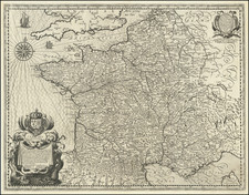
Fine English Wall Map of Napoleon's Empire of France.
Full wash color example of this rare antique wall map of France published by William Faden during the first years of the French Empire under Napoleon.
The map is based on the famed Cassini survey of France and includes updates of French territory to match the territory conquered by Napoleon up to the point of publication.
The map notes below the title the addition of two new French Departments, Mont Blanc and the Maritime Alps.
Rarity
The map is apparently very rare. We note only a single example at auction in the past 20 years.
We note an 1856 reference to the acquisition of the map for the Royal Geographical Society Map Room.
William Faden (1749-1836) was the most prominent London mapmaker and publisher of the late-eighteenth and early-nineteenth centuries. His father, William Mackfaden, was a printer who dropped the first part of his last name due to the Jacobite rising of 1745.
Apprenticed to an engraver in the Clothworkers' Company, he was made free of the Company in August of 1771. He entered into a partnership with the family of Thomas Jeffreys, a prolific and well-respected mapmaker who had recently died in 1771. This partnership lasted until 1776.
Also in 1776, Faden joined the Society of Civil Engineers, which later changed its name to the Smeatonian Society of Civil Engineers. The Smeatonians operated as an elite, yet practical, dining club and his membership led Faden to several engineering publications, including canal plans and plans of other new engineering projects.
Faden's star rose during the American Revolution, when he produced popular maps and atlases focused on the American colonies and the battles that raged within them. In 1783, just as the war ended, Faden inherited his father's estate, allowing him to fully control his business and expand it; in the same year he gained the title "Geographer in Ordinary to his Majesty."
Faden also commanded a large stock of British county maps, which made him attractive as a partner to the Ordnance Survey; he published the first Ordnance map in 1801, a map of Kent. The Admiralty also admired his work and acquired some of his plates which were re-issued as official naval charts.
Faden was renowned for his ingenuity as well as his business acumen. In 1796 he was awarded a gold medal by the Society of Arts. With his brother-in-law, the astronomer and painter John Russell, he created the first extant lunar globe.
After retiring in 1823 the lucrative business passed to James Wyld, a former apprentice. He died in Shepperton in 1826, leaving a large estate.

![Le Costa della Francia sul mare Oceano [The Coast of France on the Oceanic Sea]](https://storage.googleapis.com/raremaps/img/small/90844.jpg)