|
||

|

|
|

|
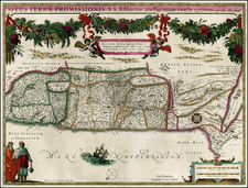
Decorative map showing the wanderings of the Apostles throughout the Holy Land and the Eastern Mediterranean, with various explanatory notes. Includes a large inset of the Holy Land and a town plan of Jerusalem, based upon Villalpando. The map has been backed on linen and folded into quarters. There is trimming to the right and left margins, with loss of the neatline on the left and some loss on the right. The map is also a bit soiled and abraided. In all, still a good example of this scarce biblical map, which would ordinarily sell for about $500 in better condition.
Nicholas Sanson (1600-1667) is considered the father of French cartography in its golden age from the mid-seventeenth century to the mid-eighteenth. Over the course of his career he produced over 300 maps; they are known for their clean style and extensive research. Sanson was largely responsible for beginning the shift of cartographic production and excellence from Amsterdam to Paris in the later-seventeenth century.
Sanson was born in Abbeville in Picardy. He made his first map at age twenty, a wall map of ancient Gaul. Upon moving to Paris, he gained the attention of Cardinal Richelieu, who made an introduction of Sanson to King Louis XIII. This led to Sanson's tutoring of the king and the granting of the title ingenieur-geographe du roi.
His success can be chalked up to his geographic and research skills, but also to his partnership with Pierre Mariette. Early in his career, Sanson worked primarily with the publisher Melchior Tavernier. Mariette purchased Tavernier’s business in 1644. Sanson worked with Mariette until 1657, when the latter died. Mariette’s son, also Pierre, helped to publish the Cartes générales de toutes les parties du monde (1658), Sanson' atlas and the first French world atlas.
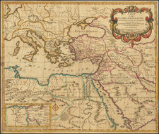
![[ Armenia, Azerbaijan, Georgia, Northern Iran, Northeastern Turkey ] The Countries Between The Caucus and Euphrates](https://storage.googleapis.com/raremaps/img/small/102209.jpg)