|
||

|

|
|

|
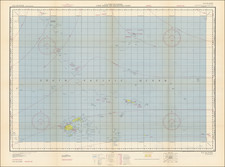
The German Dunkirk. Annotated Map Showing Soviet Harassment of German Evacuation Efforts in the Dying Days of the Second World War.
Hand-annotated high-level Soviet military map showing the Russian campaign to limit the evacuation of German forces from areas under Soviet attack as part of Operation Hannibal. The work focuses on the site of the German army's last stand in Pomerania - a small, flat spit of land jutting into the Baltic named the Hel Peninsula - and the map traces the continuation of Soviet offensives for three days following VE-day. Members of the Soviet Air Force annotated the map to show German defense lines, Soviet army movements, and aerial sorties against the Hel Pocket.
Signed by Л. Ф. Коломиец (L. [P.?] F. Kolomyets) in the upper right, this map shows the '"Oбстановка к 13.30 11.5;" the military situation updated to 1:30 P.M. on May 11th, 1945. This was three days after the official and unconditional German surrender and three days before the final capitulation of the Hel Pocket that housed Germans evacuated from Danzig. On the map, the Hel Pocket and other apparent German pockets are shown circled in blue, while advances of the Russian army and the changing frontlines are shown in red.
The map acts as an important primary source for one of the many enduring legacies of the war - the displacement of German colonizers by Soviet troops. German civilians and troops who could flee the advancing Red Army did, while those who did not were either forcibly repatriated or sent to work camps. This complete unraveling of the German social structure that had ruled Eastern European areas for the wartime era was necessary for the complete Soviet control of the region in the postwar period. This was most visible in Danzig, now Gdansk, which had been one of the earliest cities annexed by the growing Prussian state and was possibly the most important center of German history in Eastern Europe. The evacuations of civilians and armed forces from this city over a period of months was a key geopolitical factor in the establishment of the postwar Polish state.
The map is a remarkable piece of evidence that shows the atrocities that can occur when a war is already won. Notes in the North Sea show an accumulation of 90 ships near Hel. these ships and the civilians they were evacuating were relentlessly shelled for months until the final surrender on May 14th. The horrid conditions on this sandbank were not well-documented and are little known today - mass graves are repeatedly and unexpectedly discovered with more yet to be found.
The end of wars can be joyous occasions, but they are more often than not hurried mass-exoduses of civilians. This map captures this horror for the German citizens of Danzig and those caught in the fall of the once-strong German Third Reich.
Manuscript Annotations
Manuscript annotations are made in four colors throughout the map. Red is used to indicate Russian positions and troop movements while blue indicates German front lines and pockets. Annotations are contemporaneous to several different times: the earliest annotation appears to be from early 1945, with a frontline extending from Warsaw to the coast. "Crossed-arrow" symbols are shown on either side of this frontline in different colors - these appear to be airforce bases. Soviet positions, including air force positions (noted as BBC), shock army divisions (цад), and other army subdivisions are shown.
The map appears to have then been updated following the fall of Danzig and the creation of German pockets. These remaining annotations must date from late April or May given their content (e.g., showing a reduced German pocket to the north of Danzig). Here, German pockets around Danzig, Hel, Koszalin, and other locals are marked. The purported German airfields are encircled in red, likely demonstrating their capture by Soviet troops.
One of the most interesting features that date from this period is an arrowed configuration that tracks from the south of Kaliningrad across towards the German Gdansk beachhead and the Hel peninsula, before returning east. Due to the provenance of this map and the airfield symbol hypothesis proposed, this is taken to represent an areal sortie by Soviet forces. A circled point on this sortie possibly represents a ship sighting. German ships leaving Gdansk were overcrowded with civilians and easily targeted by Soviet submarines, leading to tens of thousands of lives lost.
The last class of annotations are those that are definitively dated on the map. These include a claim that ninety ships are spotted near Hel, dated to the 5th of May. Elsewhere, observations relating to a pocket near Koszalin are dated to the 12th.
The Hel Pocket
The unconditional surrender of German forces on the 8th of May, 1945, did not lead to the immediate cessation of hostilities. This map is evidence of the efforts of the Soviet Army to harass and extinguish German resistance efforts and efforts for the movement of ethnic Germans to areas surrendering to the western allies, termed Operation Hannibal by German leadership. This mass exodus had started in January of 1945 but had been mostly suppressed until the fall of Danzig became inevitable. The overall relocation of the German citizens of Danzig, at times using fishing boats and other civilian watercraft, was the largest evacuation effort of the war and surpassed British and French efforts at Dunkirk
Once Danzig fell, Germans relocated to small pockets of resistance around the city. The most important of these was on the Hel Peninsula, located on a spit of land that faces Danzig. With an easily accessible port, German vessels were able to continue evacuations until even after the war finished. Resistance here continued for well over a month following the surrender of Gdansk and even outlasted the German capitulation. The final surrender of troops on Hel is reported as having occurred on the 14th of May, six days after the surrender in Berlin.
Provenance
Commander Л. Ф. Коломиец, his signature following the title in the upper right of the map. From there, to the present owner in the Maliyutin family, by way of a family member who served as a pilot in the Soviet Air Force.
Rarity
Hand-annotated maps from Soviet forces invading the German homeland are uncommon, although they do appear on the market with some regularity. This map is the first map that we have been able to trace as appearing on the market to relate to Operation Hannibal. It is also one of the more extensively annotated maps we have seen, with significant additions that are not duplicated on other digitized maps we trace. It is also the first map we have handled to show Soviet operations following the unconditional surrender of German troops.

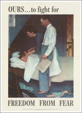
![(WWII Propaganda Map) Newsmap for the Armed Forces. 257th Week of the War - 139th Week of U.S. Participation. Monday, 14 August 1944. Volume III, No. 17B [and] No. 17F. [on verso:] Let This Do Your Talking!](https://storage.googleapis.com/raremaps/img/small/95408.jpg)