


|
||

|

|
|

|
Learning the World—An Instructional Atlas Map
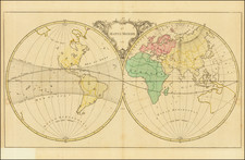
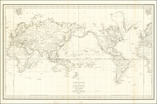
Fine double-hemisphere map of the world, the final entry in a sequence of three world maps which featured in Jean Palairet’s Atlas méthodique, composé pour l'usage de son altesse sérénissime Monseigneur le Prince d'Orange et de Nassau (1755).
Palairet, an accomplished teacher, tutored the children of George II of Britain and later served as the Agent to the Dutch States General in London. He gathered his pedagogical ideas for teaching geography in this atlas, which was sold in London, Amsterdam, Berlin, and the Hague. The maps were engraved by Thomas Kitchin, who frequently collaborated with Palairet. The atlas was meant to be used alongside a companion geography text.
Palairet thought that it was inappropriate to overload a pupil with data. In the preface to the atlas, he explains, “the maps are so loaded, so confused, or so small, that the eye finds and distinguishes only with difficulty, the considerable places, among those whose names put little, or not at all, to be noticed: hence, the disgust.”
To combat this, Palairet included multiple maps of the same place, adding more and more detail to each iteration. A student was supposed to memorize all the information on a map before moving on to next. As he writes, again in the preface to the atlas:
The Atlas is made up of Maps of the same size as those of Mr de l'Isle. There are several for each country of the world, the knowledge of which is necessary or interesting; so that instead of presenting all that is essential at the same time and from a single point of view, the first map of a continent, or of a country, is only loaded as much as necessary, so that the objects are arranged in the memory, by degrees, and in the way in which one must know them, in order to study successfully. The second, by repeating the same things, contains new ones, and so on others, until they are sufficiently filled, without being too much.
The Maps are illuminated in a particular way, which will facilitate the study of the respective situation of the States, provinces, rivers, &c.
This method seems to have worked, as eight surviving puzzles made from these maps are in the collections of the Victoria & Albert Museum today. These dissected maps were made at the request of Lady Charlotte Finch, the Royal Governess, who commissioned them for the children of George III.
The first world map includes the names for oceans and continents, the equator and the ecliptic, the Tropics of Capricorn and Cancer, the Arctic and Antarctic Circles, the North and South Poles, and the directions of the compass. An ornate cartouche is included between the two hemispheres.
The second world map adds the climatic zones on the eastern hemisphere and the shading of the main trade winds between the tropics in the western hemisphere.
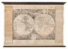
This third map completes the sequence. It includes place names, the tracks of important historical voyages, and the antipodes of significant European cities in the South Pacific, near the partial coast of New Zealand.
The Pacific Northwest is left largely blank. Greenland is connected to North America, making a Northwest Passage difficult to imagine. However, text on the unfinished coast in the northwest states, “we have no sure knowledge of the limits on this side.”
There is no southern continent, but there are several curious configurations. In the North Pacific, north of Japan, are open shores near Jedso. This is Terre de la Compagnie, part of a series of chimeric islands in that area.
By far the strangest feature is the gargantuan outline of Australia, which extends far to the west to Terre du S. Esprit. This is an amalgamation of the Dutch encounter of what they called New Holland with Pedro Fernandes de Quiros’ Austrialia de Espiritu Santo, which is actually Vanuatu, and New Guinea.
The ships’ tracks show the routes of Spanish treasure galleons to and from Manila and Acapulco. Near these is the route of Anson, who led a circumnavigation in 1740-44 that captured one of these galleons. When these maps were made, in the early 1750s, the voyage was one of the most well-known in the world, thanks to the popularity of the 1748 voyage account of the expedition.
Quiros’ Espiritu Santo
Quiros had contacted Vanuatu on his second Pacific voyage of 1605. He thought it was part of a continent and told officials in Europe as much. He died before he could mount another expedition, but his ideas were reprinted in prominent voyage collections into the eighteenth century.
Cartographically, there was variation in the placement of a hypothetical eastern Australian coastline that included Espiritu Santo. One of the earliest maps to show this depiction seems to have been Guillaume Delisle’s 1714 map of the southern hemisphere. The map shows Espiritu Santo with the Jordan and San Salvador rivers at roughly 185°E (from an Atlantic prime meridian), but it is not connected to New Holland. Others also adopted the idea of an Australian continent stretching to Espiritu Santo, including Richard Cushee in his 38 cm. diameter terrestrial globe of 1731.
The idea of a hypothetical eastern coast, evident in the famed Bonaparte Tasman map, was revived in the 1740s and 1750s. One of the world maps in John Campbell’s collection, by Emmanuel Bowen, shows T. de St. Espirit at 150°E (Greenwich meridian) as part of a suggested eastern coastline for Australia.
In 1753, Bellin connected Van Diemen’s Land to Espiritu Santo (145°E, Paris meridian), but added a note explaining the link as unproven. Robert de Vaugondy’s map of 1756 also connects the two into a large continent with New Holland (Espiritu Santo at 170°E, with an Atlantic meridian). Interestingly, the latter map was included in Charles De Brosses’ voyage collection, wherein De Brosses expressed his belief that Espiritu Santo was insular.
North Pacific chimeras: Yesso, De Gama, and Compagnie Land
The etymology of the idiom Yesso (Eso, Yeco, Jesso, Yedso) is most likely the Japanese Ezo-chi; a term used for the lands north of the island of Honshu. During the Edō period (1600-1886), it came to represent the ‘foreigners’ on the Kuril and Sakhalin islands. As European traders came into contact with the Japanese in the seventeenth century, the term was transferred onto European maps, where it was often associated with the island of Hokkaido. It varies on maps from a small island to a near-continent sized mass that stretches from Asia to Alaska.
The toponym held interest for Europeans because the island was supposedly tied to mythic riches. Father Francis Xavier (1506-1552), an early Jesuit missionary to Japan and China, related stories that immense silver mines were to be found on a secluded Japanese island; these stories were echoed in Spanish reports. The rumors became so tenacious and tantalizing that Abraham Ortelius included an island of silver north of Japan on his 1589 map of the Pacific.
Yesso is often tied to two other mythical North Pacific lands, Gamaland and Compagnies Land. Juan de Gama, the grandson of Vasco de Gama, was a Portuguese navigator who was accused of illegal trading with the Spanish in the East Indies. Gama fled and sailed from Macau to Japan in the later sixteenth century. He then struck out east, across the Pacific, and supposedly saw lands in the North Pacific. These lands were initially shown as small islands on Portuguese charts, but ballooned into a continent-sized landmass in later representations.
Several voyagers sought out these chimerical islands, including the Dutchmen Matthijs Hendrickszoon Quast in 1639 and Maarten Gerritszoon Vries in 1643. Compagnies Land, often shown along with Staten Land, were islands sighted by Vries on his 1643 voyage. He named the islands for the Dutch States General (Staten Land) and for the Dutch East India Company (VOC) (Compagnies, or Company’s Land). In reality, he had re-discovered two of the Kuril Islands. However, other mapmakers latched onto Compagnies Land in particular, enlarging and merging it with Yesso and/or Gamaland.
In the mid-eighteenth century, Vitus Bering, a Danish explorer in Russian employ, and later James Cook would both check the area and find nothing. La Perouse also sought the huge islands, but found only the Kurils, putting to rest the myth of the continent-sized dream lands.
Thomas Kitchin was a British cartographer and engraver. Born in Southwark, England, Kitchin was the eldest of several children. He was apprenticed to the map engraver Emanuel Bowen from 1732 to 1739, and he married Bowen’s daughter, Sarah, in December 1739. By 1741 Kitchin was working independently and in 1746 he began taking on apprentices at his firm. His son Thomas Bowen Kitchin was apprenticed to him starting in 1754. By 1755 Kitchin was established in Holborn Hill, where his firm produced all kinds of engraved materials, including portraits and caricatures. He married his second wife, Jane, in 1762. Beginning in 1773 Kitchin was referred to as Hydrographer to the King, a position his son also later held. He retired to St. Albans and continued making maps until the end of his life.
A prolific engraver known for his technical facility, clean lettering, and impressive etched decorations, Kitchin produced several important works throughout his career. He produced John Elphinstone’s map of Scotland in 1746, and the first pocket atlas of Scotland, Geographia Scotiae, in 1748/1749. He co-published The Small English Atlas in 1749 with another of Bowen’s apprentices, Thomas Jefferys. He produced The Large English Atlas serially with Emanuel Bowen from 1749 to 1760. The latter was the most important county atlas since the Elizabethan era, and the first real attempt to cover the whole country at a large scale. In 1755 Kitchin engraved the important John Mitchell map of North America, which was used at the peace treaties of Paris and Versailles. In 1770 he produced the twelve-sheet road map England and Wales and in 1769–70 he produced Bernhard Ratzer’s plans of New York. In 1783, he published The Traveller’s Guide through England and Wales.
Jean Palairet (1697-1774) was a mapmaker and teacher. He was born in Montauban, France, but emigrated to England as a young man. He worked as an agent for the French States General and as the French tutor to the children of George II. Later, he served as the Agent to the Dutch States-General in London. He wrote works on orthography and French grammar, as well as published a geography primer, a teaching atlas, and his more famous map of the colonies with an accompanying pamphlet.
![Western Hemisphere. Eastern Hemisphere. [showin the Republic of Texas]](https://storage.googleapis.com/raremaps/img/small/82886.jpg)