|
||

|

|
|

|
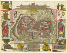
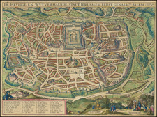
Antique engraved town plan of Jerusalem, based upon prophecies, engraved by Jan Luyken, and published by Pieter Mortier in 1707.
Numerous landmarks are rendered pictorially throughout the town plan itself, with twin legends held aloft by cherubs showing 57 sites.
The map is surrounded by twelve Old Testament vignettes, including Solomon's Temple, the Ark of the Covenant, etc.
Luyken had a characteristic engraving style that favored dense linework and complex imagery.
Rarity
This is the first time we have had this map.
Pierre, or Pieter, Mortier (1661-1711) was a Dutch engraver, son of a French refugee. He was born in Leiden. In 1690 he was granted a privilege to publish French maps in Dutch lands. In 1693 he released the first and accompanying volume of the Neptune Francois. The third followed in 1700. His son, Cornelis (1699-1783), would partner with Johannes Covens I, creating one of the most important map publishing companies of the eighteenth century.