|
||

|

|
|

|
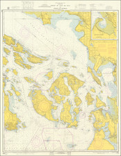
Rare Storm Chart for the North Pacific
Fascinating informational graphic, illustrating details of storm activity in the North Pacific, as observed by ships operating in these waters and reported to the US Hydrographical Office.
The map tracks storm and rain details by quadrants, with longitude and latitude shown to track the entire North Pacific covered in meticulous details.
The data compiled in this chart would have been derived from whaling ships and the increasing trade on the West Coast of North America, following the California Gold Rush of 1849. The chart notes "the object of this chart is to show the exceptions to what may generally be considered the prevailing condition of weather at sea and to determine from what quarter storms are most liable to occur foreach month in every district.
While not obvious at first glance, the chart is intended to illustrate the North Pacific, with the contour of the table at the right matching the contour of the Pacific Coast of North America.
The work was overseen by Matthew Fontaine Maury, who earned the nicknames "Pathfinder of the Seas" and "Father of Modern Oceanography and Naval Meteorology" for his extensive works in his books, especially The Physical Geography of the Sea (1855), the first such extensive and comprehensive book on oceanography to be published.
The present chart, issued in 1860, would be Maury's last such compilation prior to the outbreak of the American Civil War, which saw Maury fight on behalf of his beloved Virginia and then remain outside of the United States after the end of the Civil War (1861-1865), spending 1865 to 1868 in Maximilian's Mexico and England, before returnig to the US in 1868.
Lieutenant Maury's Work on Hydrography
Maury's seminal work on the Oceans currents and related atmospheric phenomena was commenced in 1847, with the publication of his map of the currents of the North Atlantic (Schwartz & Ehrenberg 278) and culminated with The Physical Geography of the Sea, published in 1855. While preparing the charts Maury sought the cooperation of mariners from many nations, getting them to report to him their regular observations of winds and currents, which he either added or corrected on his own charts.
This was the Age of the great clipper ships, and their masters prized Maury's charts. By following their wind and current directions, they were able to cut many days off their voyages from North American ports to Europe and Asia, as well as from New York to San Francisco.
Maury was the chief Naval Officer in charge of charts from 1843 to 1861. His work describing seasonal winds and currents was conceived largely outside conventional academic circles. Maury was made an honorary member of the Boston Marine Society, where his portrait was hung, and later turned upside down when he later elected to join the Confederacy during the American Civil War.
Rarity
The chart is extremely rare. It was only issued in a single year, as Maury's work was interrputed by the American Civil War. While the similar charts of the Atlantic appeared as early as 1853 and come to market occasionally, the North Pacific is virtually unobtainable.
We locate only the examples at, Yale, Royal Maritime Museum (Greenwich), John Carter Brown, State Library of Virginia and American Geographical Society (U of Wisconsin, Milwaukee).