|
||

|

|
|

|
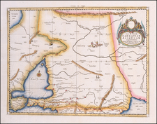
Intriguing original antique map showing the part of the world conquered by Alexander the Great in the fourth century B.C. Published in the latter half of the 18th-century in France by Philippe de Pretot during a period in which interest in classical history was on the rise, this delightful map shows roads, rivers, and mountain ranges throughout the region.
The map stretches from Eastern Europe and Ukraine through to Egypt and the Indus River (and the Beas, where Alexander famously turned back). The map is centered on Babylon, where Alexander the Great planned to establish his capital.
The map includes a decorative cartouche showing a Greek field camp. Detail on the map is extensive, and the roads connecting the major cities are of particular interest for showing how trade functioned.
Pretot was a French schoolmaster and geographer active in the second half of the eighteenth century. A student of history, Pretot was a member of both the Academies Royales des Sciences et Belles-Artes de Rouen and d'Angers.
![Asia Minor [shows Cyprus]](https://storage.googleapis.com/raremaps/img/small/73408.jpg)
![Turkey in Asia [with Cyprus]](https://storage.googleapis.com/raremaps/img/small/59273.jpg)
![Regionis Ponti Pars Orientalis quam Mosaicis temporibus Nobilitarunt Caphtoraei et Heroicis Claram reddidere Tibareni, Genetes, Chalibes, Halizones, Mosyni, Philyres &c... [The eastern part of the region of the Pontus, which in the Mosaic times was ennobled by the Caphtoraei and the Heroics, to give glory to the Tibareni, Genetes, Chalibes, Halizones, Mosyns, Philyres, &c...]](https://storage.googleapis.com/raremaps/img/small/82074.jpg)