|
||

|

|
|

|
Stock# 82741
Description
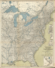
Decorative example of Humphrey Phelps' 1855 map of the United States.
This edition of the map has been revised from earlier editions, and includes a large inset of the Western States, including a massive Nebraska Territory and oversized Washington, Oregon, Utah and New Mexico Territories, with Kansas extending into modern Colorado and Minnesota including much of the Dakotas.
The whole is surrounded by a fine decorative border depicting 30 alternating state seals and 16 important historical figures.
A large part of the Eastern parts of Texas and Indian Territory are shown.
![Carte Generale Des Etats Unis De L'Amerique Septentrionale Renfermant Aussi Quelques Provinces Angloise . . . [Shows State of Franklin!]](https://storage.googleapis.com/raremaps/img/small/98580.jpg)
![[ Atlas of The United States ] Karte von Amerika](https://storage.googleapis.com/raremaps/img/small/84353mp2.jpg)