|
||

|

|
|

|
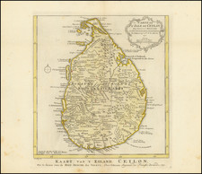
The Earliest Obtainable Map of Sri Lanka
Nice example of the Swenheym's Ptolemaic map of Sri Lanka, from the 1490 edition of his Ptolemy. This map shows the marvelous classical mapping of the island of Sri Lanka, as first "produced" two centuries after Christ. This map was first published in 1478 as part of the first set of maps ever issued and is here reissued in the second 1490 printing.
Swenheym's finely engraved of Sri Lanka is the earliest obtainable map of the region, preceded only by a map published in Bologna in 1477 that is essentially unobtainable for collectors. The map shows the region based on the writings of the Alexandrian mapmaker Claudius Ptolemy, who flourished in the second century A.D. and whose geographical text was translated into Latin and later inspired manuscript maps using Ptolemy's table of geographical coordinates.
The geography of the island as portrayed on the map would persist as the definitive mapping of Sri Lanka throughout the 15th and 16th centuries. For a cartography developed in Greece, thousands of miles away from this island, the fact that it even appears on maps is a remarkable feat in and of itself. It is even possible that the mountains of southern Sri Lanka, the "Malaea Mons," are a real reference to this high country.
Tooley describes the engraving nature of the maps in the Rome Ptolemy as: "superb testimonials of Italian craftsmanship without the picturesque but unscientific monsters of the medieval maps or the addition of the adventitious decoration of later work, relying for their beauty solely on the delicacy of their execution and the fineness of the material employed."
The 1478 Rome Ptolemy
In the early 1470s, Conrad Swenheym set out to produce the first illustrated printed edition of Ptolemy's Cosmographia. He is widely thought to have been present at the birth of printing while an apprentice of Johann Guttenberg in Mainz. Swenheyn and Arnold Pannartz are famous for introducing the first printing press to Italy in 1464-5.
Pope Paul II became so enthusiastic about the new medium that he lavishly sponsored Swenheym and Pannartz's work, setting them up at the Massimi Palace in Rome. Unfortunately, when the pope died in 1471, the new pontiff, Sixtus IV, disavowed the project, so delaying its progress. However, by 1474, Swenheym is recorded as having trained "mathematicians" to engrave maps on copper. Swenheym's edition of Ptolemy was eventually published by Arnold Buckinck in 1478, one year after Swenheym's death.
The 1478 Rome edition of Ptolemy's work is of tremendous importance to the history of printing as the first set of maps to employ the "punched letter" printing process. They are also an early record of the Ptolemaic cartographies that influenced the Medieval World's geographical understanding of the world. The earliest surviving examples of such manuscript maps date to the beginning of the 14th Century. Ultimately these maps and Ptolemy's text would be compiled to form the most influential treatise on Geography in the 15th Century, concurrently with the advent of the printing press, resulting in its widespread distribution in Europe, which ironically eclipsed the work of other Greek Geographers of the period, such as Strabo, whose work was probably more accurate than Ptolemy's calculations.
Despite being beaten out by one year (for the honor of the earliest printed edition of Ptolemy's work) by Taddeo Crivelli, who published his edition in in Bologna in 1477, the copper plates produced under Swenheym's close supervision, and finally printed just after his death in 1478, are considered vastly superior. The plates were then purchased by Petrus de Turre in 1490, who published the second edition, in which this map appeared. The only difference in the maps are the watermarks in the paper. A third edition was issued in 1507.
Claudius Ptolemy (fl. AD 127-145) was an ancient geographer, astronomer, and mathematician. He is known today through translations and transcriptions of his work, but little is known about his life besides his residence in Alexandria.
Several of his works are still known today, although they have passed through several alterations and languages over the centuries. The Almagest, in thirteen books, discusses astronomy. It is in the Almagest that Ptolemy postulates his geocentric universe. His geometric ideas are contained in the Analemma, and his optical ideas were presented in five books known as the Optica.
His geographic and cartographic work was immensely influential. In the Planisphaerium, Ptolemy discusses the stereographic projection. Perhaps his best-known work is his Geographia, in eight books. However, Ptolemy’s ideas had been absent from western European intellectual history for roughly a thousand years, although Arab scholars interacted with his ideas from the ninth century onward.
In 1295, a Greek monk found a copy of Geographia in Constantinople; the emperor ordered a copy made and the Greek text began to circulate in eastern Europe. In 1393, a Byzantine diplomat brought a copy of the Geographia to Italy, where it was translated into Latin in 1406 and called the Cosmographia. The manuscript maps were first recorded in 1415. These manuscripts, of which there are over eighty extant today, are the descendants of Ptolemy’s work and a now-lost atlas consisting of a world map and 26 regional maps.
When Ptolemy’s work was re-introduced to Western scholarship, it proved radically influential for the understanding and appearance of maps. Ptolemy employs the concept of a graticule, uses latitude and longitude, and orients his maps to the north—concepts we take for granted today. The Geographia’s text is concerned with three main issues with regard to geography: the size and shape of the earth; map projection, i.e. how to represent the world’s curve proportionally on a plane surface; and the corruption of spatial data as it transfers from source to source. The text also contains instructions as to how to map the world on a globe or a plane surface, complete with the only set of geographic coordinates (8000 toponyms, 6400 with coordinates) to survive from the classical world.
![(Temple of the Sacred Tooth) [Kandy Lake, Sri Lanka]](https://storage.googleapis.com/raremaps/img/small/90505.jpg)
![[Sri Lanka] Tabula Asiae XII](https://storage.googleapis.com/raremaps/img/small/87852.jpg)