


|
||

|

|
|

|
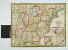
The March of the Mounted Rifiemen of 1849 -- The "Extreme Limit of Line of Frontier Stations" of the American West
Remarkable map of the American West, focusing on the Old and New Frontier Stations, Lines of Land, River and Water Communications, American Froniter Posts and the trek of the Mounted Riflemen in 1849, taking control of Oregon Territory following the conclusion of the Mexican War and shortly after the discovery of Gold in California.
The detail in the West and Texas provides one of the most comprehensive snapshots of American Forts, Frontier Stations and Posts west of the Mississippi River. A line from the mouth of the Sabine River in Louisiana north to Lake Superior indicates the "Extreme Limit of Line of Frontier Stations." Stations to the east of this line were primarily accessible by steamboat and railroads while stations to the west of the line were reached by wagon only.
This rare map is of considerable interest for the early exploration of the Transmississippi West. it is the only known map to report on the March of the Mounted Riflemen in 1849. This regiment, under the command of Colonel William Wing Loring, marched from Ft. Leavenworth to the Columbia River, with wagons. Loring was ordered to take command of the Oregon Territory and led a train of 600 mule teams 2,500 miles from Missouri to Oregon. The regiment passed over the same route as the 1849 Stansbury Expedition to the Great Salt Lake, proceeding as far as the Bear River (northeast of the Great Salt Lake), then followed the River downstream to Fort Hall. From there, Loring's regiment followed the Snake River to Fort Boise,through the Grande Ronde and over the Blue Mountains to Fort Walla-Walla, 30 miles east of the Columbia River.
This trip resulted in a report ( Report...of the March of the Regiment of Mounted Riflemen to Oregon, from May 10, to October 5, 1849), but no map. The only map to show this expedition was issued in 1851. As noted by Carl Wheat:
The Mexican War had been over long enough for the Topographical Engineers to catch their breath, and a number of worthwhile maps resulted. An undated and untitled map of frontier posts and of lines of land and sea communications to the Pacific Coast is of particular interest, since it shows the "old frontier stations," both occupied and abandoned, and "new frontier stations," including those "recently abandoned." Its provenance has not been learned, but a copy is preserved at Yale University, and it was drawn and lithographed (by "P. S. Duval's Steam Lith. Press, Philada.") prior to the Gadsden Purchase of 1853.
[The map] is apparently the only published map showing the March of the Mounted Rifiemen of 1849, the Fremont-Gibbs-Smith map having contained only George Gibbs' penciled notations on that interesting expedition,* A line showing the "Extreme limit of line of frontier stations on the 30th June 1845" extends from the mouth of the Sabine on the south, past Forts Jesup, Washita, Gibson, Scott, Leavenworth, Atkinson, and Snelling to Ft. Wilkins on Lake Superior. West of this line appear many new military posts, disclosing the efForts then being made by the Army to afford protection to the flood of emigrants who by this time were moving westward by every practicable route. As for the map itself, its far west is somewhat of a curiosity, with a single eastwest range of mountains through the center of the Great Basin merging with mountains south of Great Salt Lake, which in turn join a north-south range. The group of ranges is labeled "Dividing Range between the Waters of the Pacific and of the Atlantic," but without apparent recognition of the Great Basin's real nature. As a map, this document is somewhat of a throwback,but for its frontier information it amply deserves attention. It was probably used to illustrate a Congressional report not yet identified by the writer.
In his subsequent opus work, Mapping of the Transmississippi West, Wheat dedicates 3 pages in Volume III (pp 114-116) to this map, which he notes was published in an 1851 Congressional Report (32nd Congress, 1st Session, Sen Ex. Doc No. 1, Serial 611, opposite page 304).
States of the Map / Rarity
There are apparently two states of the map, which can be differentiated by the Duval imprint at the bottom right corner (1851 state), with a later version, issued for General Jessup's report in the same year, lacking the Duval imprint).
Both maps are rare on the market.
![(Mexican-Aztec Artwork) [Original pencil tracing of Aztec Calendar]](https://storage.googleapis.com/raremaps/img/small/102327.jpg)