


|
||

|

|
|

|
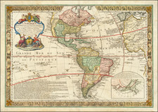
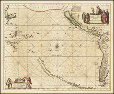
Scarce map of America, published in Amsterdam by Gerard Valk.
Valk's map of California shows many of the most fascinating myths of the 17th Century. California is shown as an island on the so-called "second Sanson Model." A massive land bridge extends from just west of Capo Blanco on the northern California coastline to Niphon, a curious adaptation of the legend of Compagnie Land (shown here as a place name -- Terre de la Compagnie) and the continuous land bridge from America to Asia, although adding the Detroit de Tzungaar (Strait of Tzungaar), a very rarely mentioned mythical Strait between two islands of Japan.
The Great Lakes are oddly configured, with Lake Superior and Lake Michigan open ended to the West. The Mississippi River is very ill conceived, pre-dating the radical improvements which would come with Guilluame De L'Isle's map of North America of 1700 and Carte du Mexique of 1703.
The fine allegorical cartouches depict the booming trade then being conducted by Europeans in the New World.
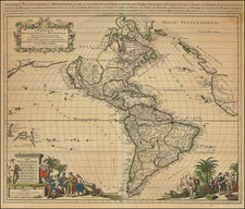
The popular misconception of California as an island can be found on European maps from the sixteenth through the eighteenth centuries. From its first portrayal on a printed map by Diego Gutiérrez, in 1562, California was shown as part of North America by mapmakers, including Gerardus Mercator and Abraham Ortelius. In the 1620s, however, it began to appear as an island in several sources. While most of these show the equivalent of the modern state of California separated from the continent, others, like a manuscript chart by Joao Teixeira Albernaz I (ca. 1632) now in the collection of the National Library of Brasil shows the entire western half of North Americas as an island.
The myth of California as an island was most likely the result of the travel account of Sebastian Vizcaino, who had been sent north up the shore of California in 1602. A Carmelite friar, Fray Antonio de la Ascensión, accompanied him. Ascension described the land as an island and around 1620 sketched maps to that effect. Normally, this information would have been reviewed and locked in the Spanish repository, the Casa de la Contratación. However, the manuscript maps were intercepted in the Atlantic by the Dutch, who took them to Amsterdam where they began to circulate. Ascensión also published descriptions of the insular geography in Juan Torquemada’s Monarquia Indiana (1613) (with the island details curtailed somewhat) and in his own Relación breve of ca. 1620.
The first known maps to show California as an island were on the title pages of Antonio de Herrera’s Descripción de las Indias Occidentales (1622) and Jacob le Maire's Spieghel Der Australische Navigatie (1622). Two early examples of larger maps are those by Abraham Goos (1624) and another by Henry Briggs, which was included in Samuel Purchas’ Hakluytus Posthumus or Purchas his Pilgrimes (1625). In addition to Briggs and Goos, prominent practitioners like Jan Jansson and Nicolas Sanson adopted the new island and the practice became commonplace. John Speed’s map (1626-7), based on Briggs’ work, is well known for being one of the first to depict an insular California.
The island of California became a fixture on mid- and late-seventeenth century maps. The island suggested possible links to the Northwest Passage, with rivers in the North American interior supposedly connecting to the sea between California and the mainland. Furthermore, Francis Drake had landed in northern California on his circumnavigation (1577-80) and an insular California suggested that Spanish power in the area could be questioned.
Not everyone was convinced, however. Father Eusebio Kino, after extensive travels in what is now California, Arizona, and northern Mexico concluded that the island was actually a peninsula and published a map refuting the claim (Paris, 1705). Another skeptic was Guillaume De L’Isle. In 1700, De L’Isle discussed “whether California is an Island or a part of the continent” with J. D. Cassini; the letter was published in 1715. After reviewing all the literature available to him in Paris, De L’Isle concluded that the evidence supporting an insular California was not trustworthy. He also cited more recent explorations by the Jesuits (including Kino) that disproved the island theory. Later, in his map of 1722 (Carte d’Amerique dressee pour l’usage du Roy), De L’Isle would abandon the island theory entirely.
Despite Kino’s and De L’Isle’s work, California as an island remained common on maps until the mid-eighteenth century. De L’Isle’s son-in-law, Philippe Buache, for example, remained an adherent of the island depiction for some time. Another believer was Herman Moll, who reported that California was unequivocally an island, for he had had sailors in his offices that claimed to have circumnavigated it. In the face of such skepticism, the King of Spain, Ferdinand VII, had to issue a decree in 1747 proclaiming California to be a peninsula connected to North America; the geographic chimera, no matter how appealing, was not to be suffered any longer, although a few final maps were printed with the lingering island.
Gerard Valk, or Gerrit Leendertsz Valck (1652-1726) together with his son Leonard, were the only significant publishers of globes in the Netherlands in the eighteenth century, enjoying an almost total monopoly in the first half of the 1700's. Initially an engraver and art dealer, and having worked for map-sellers Christopher Browne and David Loggan in London between 1672 and 1679, Valk established the firm in Amsterdam in 1687. Initially, they published maps and atlases, but in 1700 the company moved the shop to the building previously occupied by map and globe-maker Jodocus Hondius. In 1701, he applied for a charter for making globes and the "Planetolabium", designed by Lotharius Zumbach de Coesfelt (1661-1727), an astronomy lecturer at Leiden University. The Valks produced several editions of 3, 6, 9, 12, 15, 18 and 24-inch diameter terrestrial and celestial globes. The cartography, as stated on the cartouche, is based closely on the celestial atlas Uranographia, published in 1687 by the celebrated Polish astronomer Johannes Hevelius (1611-1687).
Around 1711, when he became a member of the bookseller's guild, Leonard Valk (1675-1746) came into partnership and his name started to appear alongside that of his father on the cartouches of the globes, although the earliest of these, both terrestrial and celestial, still bear the date 1700. Leonard naturally took over the business on his father's death in 1726, and following his own death in 1746 the firm was run by Maria Valk, cousin, and wife to Gerard. By then its days of glory had passed. Leonard Valk died in relative poverty: his wife had to take in the washing of their aunt to make ends meet. The late eighteenth century saw a number of successful reissues by publisher Cornelis Covens (1764-1825), who ran the famous cartographical publishing house of Covens & Mortier (1721-1866) in Amsterdam. This firm was the biggest Dutch one for publishing maps in the 18th century. It was located on the Vijgendam (Fig Dam), the southern part of what is now Dam Square, the central hub of the city. They didn't move out of their building, but they did change addresses. At first in 1795 the whole Dam was rebaptized into Revolution Square, then it got the name Napoleon Square, till in 1813 after Napoleon's fall Covens & Mortier were back again at the Vijgendam.
![[Nova et Acurata Totius Americae Tabula auct. G.I. Blaeu] America quarta pars orbis quam plerunq, novum orbem appellitant) primo detccta est anno 1492, a Christophoro Columbo Genuensi auspicijs Regis Castiliae, Deutde ulterius perucistigata navigationibus Americi Florentini, de cuius nomine America dicta est circiter annum 1497 Verum anno 1520 Ferdiandus Magallanus primus fuit qui extremos limites ad austru vergentes navigatione per fretum de nomine suo Magallanicu dictu uisitauit et noto fecit](https://storage.googleapis.com/raremaps/img/small/81465.jpg)