|
||

|

|
|

|
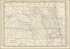
Rare First State of Warren's Pivotal Map of the American Plains, with Stellar Provenance.
First state of Gouverneur Kemble Warren's large format map of Kansas, Nebraska, Dakota and part Colorado and Wyoming, based upon surveys and reconnaissance expeditions conducted between 1823 and 1857.
First issued in late 1858, the map is one of the earliest maps to reference the Gold Regions in Kansas Territory, which would shortly thereafter become Colorado Territory on the strength of the 1859 Colorado Gold Rush. The Gold Regions on Cherry Creek are shown in the first state of the map, with the second state of the map updated to add the place name "Auraria," one of the first gold rush settlements on Cherry Creek (founded October 3, 1858) in the area which would shortly thereafter include the founding of Denver City on November 22, 1858. The first state of the map (lacking the Auraria reference) is reproduced on one of the maps in Redpath & Hinton's Kansas and Nebraska...1859, an important early guide to the gold regions, published in 1859.
Warren's extensive knowledge of the area and his great skills as a cartographer are obvious in this large, highly detailed map. It shows the topographic and geographic features from Kansas in the south to the Canadian border on the north and extends westward to the eastern edge of the Colorado Rockies and beyond the fork of the Yellowstone and Missouri Rivers.
The first state of the map was completed in 1858 and is very rare on the market. It accompanied Warren's study of the Black Hills, and the Nebraska and Dakota regions, published as an appendix to General Andrew A. Humphreys' Report of the War Department to the President (1858).
As Streeter noted:
This large scale map of the western country from the meridian of the junction of the Kansas and Missouri rivers west to the Rockies, and north to Fort Garry in Canada, based as it is on all the previous explorations, gives for the first time on one map a more or less accurate representation of the whole region. Interesting features of the map are the tracings of the routes of the various explorations from that of Long in 1823 to as late as the various explorations of 1857.
The map credits Warren with much of the survey drawn:
from the Explorations made by him in 1855-6 while attached to the staff of Brev. Brig. Gen. W.S. Harney, commg . Sioux Expedn . and in 1857 under the Direction of the Office Explns . and Surveys Capt. A.A. Humphreys in Charge Exhibiting also Routes reconnoitered & surveyed...
The map draws on the most important American Surveys, from Lewis & Clark and Major Steven H. Long, to John C. Fremont, Nicollet, Stansbury, Pope, Stevens and the work of the General Land Office. This routes of exploration, survey and road building of a number of these important historical figures are given in detail.
States of the Map
The first edition of the map is known in 3 states, as well as a second edition and third edition, with the title changed.
The various states and editions of the map are identifiable as follows:
- State 1. Two column list of explorations and surveys. No information included from after 1858.
- State 2. Bien imprint at bottom left and revised list of explorations and surveys, with the last line (Nicollet) centered.
- State 3. Colored to show Geological information. Bien imprint removed, exploration and survey tables removed, new title info and geological table added.
- Second Edition: An entirely new set of stones. List of explorers and surveys re-added, but last line is left justified. No Bien imprint and the line of the Union Pacific is now completed and shows a track pattern. The map depicts updated railway information from at least as late as 1870, most notably, the Kansas City to Denver line of the Union Pacific Railway, which was only completed that year. An updated edition of Hayden's geological version of the Warren map was also produced on the heals of the second edition.
- Third Edition: Issued in 1875. Following the discovery of gold in the Black Hills in 1874, interest in the region intensified. In response, the federal government issued G.K. Warren's Preliminary Report of Explorations in Nebraska and Dakota, in the Years 1855-56-57 (Washington, 1875), which contained the fourth edition of the map. The report was issued in 2,000 copies, ensuring that the fourth edition is today easily obtainable.
. State 2 of the map can be differentiated from State 1 of the map by the addition of the following features:
- To the right of the title, the words "Engraving Carefully Revised G.K. Warren Lieut. Top Engrs" added.
- Many place names added along the "Nebraska or Platte River" including the foregoing name, as well as O'Fallon's Bluff, Cotton Wood Spring, Brady's L.
- "River of Souls" and "Lookingglass C" are added above the Pawnees Reservation.
- Further northwest on the route surveyed by Warren in 1857, "Loup Fork" has been added.
- The name "Dakota River" is added
- The topographical features east of Laramie Peak are improved
- Along the White River, the words "White River" and "Mauvaises Terres or Bad Lands" are added.
- Mouse River is added to the west of Assiniboine River.
- Missouri River is added near St. Joseph.
- Auraria is added on Cherry Creek in the Denver area.
The nature of the foregoing changes suggests that they were intended as improvements to a proof copy of the map, rather than the result of additional surveys or new information. The University of Wisconsin-Milwaukee / American Geographical Society collection holds a proof of state 1, lacking the title, which is added in blue pencil.
Gouverneur Kemble Warren
Gouverneur Kemble Warren (1830-1882) was a civil engineer, who served as General in the Union Army during the American Civil War. After graduating from the US Military Academy, he was commissioned a brevet second lieutenant in the Corps of Topographical Engineers. From 1850 to 1853, Warren served on several important survey expeditions, including surveys of the lower Mississippi delta in 1850-1851 to explore means of flood prevention, and of the upper Mississippi rapids in 1853 to facilitate navigation of this vital trade route. From 1853 to 1855 he participated in the monumental US Pacific Railroad Survey, examining reports of all explorations west of the Mississippi back to Lewis and Clark, a study which required Warren to review the history of the explorations of what was then Nebraska Territory and Dakota Territory, which also included parts of the modern states of Kansas, Montana and Wyoming.
From 1855 to 1857, Warren made three expeditions in the Nebraska Territory, where he surveyed possible routes for roads and railroads and made extensive observations. Warren took part in studies of possible transcontinental railroad routes, collecting data for what was to be the first comprehensive map of the United States west of the Mississippi. He spent nearly a year in Washington compiling his findings into official reports and completing his Map of the United States from the Mississippi to the Pacific Ocean, which accompanied Secretary of War Jefferson Davis' final report to Congress on the results of the transcontinental railroad route investigation in 1857.
Rarity
The map is extremely rare on the market.
The map has not appeared in a dealer catalog listed in AMPR in the past 20 years.
![[ Montana ]](https://storage.googleapis.com/raremaps/img/small/101156.jpg)