
![[The 5 Californias] Carte de la Californie Suivant 1. La Carte manuscrite de l'Amerique de Mathieu Neron Pecci olen dressee a Florence en 1604, 2. Sanson 1656 . . . By Denis Diderot / Didier Robert de Vaugondy](https://storage.googleapis.com/raremaps/img/small/97983.jpg)


|
||

|

|
|

|
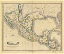
Survey of the Fine Early Maps of California
A historically important depiction of the 5 most influential cartographic depictions of California, showing the evolution of how California was mapped between 1604 and 1767.
The earliest map is (upper right corner) based upon a manuscript map by Mathieu Neron Pecci, drawn in Florence in 1604. This map also forms the basis of a map popularized in 1770 by Rigobert Bonne.
The second map is Nicholas Sanson's map of California as an Island, based upon his larger map of 1656. This map was probably the single most influential projection of California as an Island.
The third map (lower right) is a portion of Guillaume De L'Isle's map of America, published in 1700. While not truly peninsular in nature, it was influential in the shift back toward depicting California as a Peninsula.
The fourth map (upper center) is a portion of Fra. Eusebio Kino's map, generally credited with being the map which dispelled California as an Island myth. Issued in 1705, the map is based upon Father Kino's overland expedition from the mainland to the top of the Gulf of Cortez.
The fifth map is one of the most interesting and enduring maps of California and Baja (left side). Initially issued by the Society of Jesuits in 1767, it was popularized by Isaak Tirion and was perhaps the most interesting of all maps of Baja California in the 2nd half of the 18th century.
This map was 1 of 10 maps to appear in the Supplement to Diderot's monumental encyclopedia, one of the most influential and widely distributed works of the second half of the 18th century. Diderot's goal was to examine and display the popular geographical conceptions of several different parts of the world where the knowledge of the region's geography was still largely unknown and evolving. Other maps treat the Northwest Passage, Northeast Passage and the NW Coast of America, among other topics.
A marvelous amalgam and an essential map for California collectors.
The popular misconception of California as an island can be found on European maps from the sixteenth through the eighteenth centuries. From its first portrayal on a printed map by Diego Gutiérrez, in 1562, California was shown as part of North America by mapmakers, including Gerardus Mercator and Abraham Ortelius. In the 1620s, however, it began to appear as an island in several sources. While most of these show the equivalent of the modern state of California separated from the continent, others, like a manuscript chart by Joao Teixeira Albernaz I (ca. 1632) now in the collection of the National Library of Brasil shows the entire western half of North Americas as an island.
The myth of California as an island was most likely the result of the travel account of Sebastian Vizcaino, who had been sent north up the shore of California in 1602. A Carmelite friar, Fray Antonio de la Ascensión, accompanied him. Ascension described the land as an island and around 1620 sketched maps to that effect. Normally, this information would have been reviewed and locked in the Spanish repository, the Casa de la Contratación. However, the manuscript maps were intercepted in the Atlantic by the Dutch, who took them to Amsterdam where they began to circulate. Ascensión also published descriptions of the insular geography in Juan Torquemada’s Monarquia Indiana (1613) (with the island details curtailed somewhat) and in his own Relación breve of ca. 1620.
The first known maps to show California as an island were on the title pages of Antonio de Herrera’s Descripción de las Indias Occidentales (1622) and Jacob le Maire's Spieghel Der Australische Navigatie (1622). Two early examples of larger maps are those by Abraham Goos (1624) and another by Henry Briggs, which was included in Samuel Purchas’ Hakluytus Posthumus or Purchas his Pilgrimes (1625). In addition to Briggs and Goos, prominent practitioners like Jan Jansson and Nicolas Sanson adopted the new island and the practice became commonplace. John Speed’s map (1626-7), based on Briggs’ work, is well known for being one of the first to depict an insular California.
The island of California became a fixture on mid- and late-seventeenth century maps. The island suggested possible links to the Northwest Passage, with rivers in the North American interior supposedly connecting to the sea between California and the mainland. Furthermore, Francis Drake had landed in northern California on his circumnavigation (1577-80) and an insular California suggested that Spanish power in the area could be questioned.
Not everyone was convinced, however. Father Eusebio Kino, after extensive travels in what is now California, Arizona, and northern Mexico concluded that the island was actually a peninsula and published a map refuting the claim (Paris, 1705). Another skeptic was Guillaume De L’Isle. In 1700, De L’Isle discussed “whether California is an Island or a part of the continent” with J. D. Cassini; the letter was published in 1715. After reviewing all the literature available to him in Paris, De L’Isle concluded that the evidence supporting an insular California was not trustworthy. He also cited more recent explorations by the Jesuits (including Kino) that disproved the island theory. Later, in his map of 1722 (Carte d’Amerique dressee pour l’usage du Roy), De L’Isle would abandon the island theory entirely.
Despite Kino’s and De L’Isle’s work, California as an island remained common on maps until the mid-eighteenth century. De L’Isle’s son-in-law, Philippe Buache, for example, remained an adherent of the island depiction for some time. Another believer was Herman Moll, who reported that California was unequivocally an island, for he had had sailors in his offices that claimed to have circumnavigated it. In the face of such skepticism, the King of Spain, Ferdinand VII, had to issue a decree in 1747 proclaiming California to be a peninsula connected to North America; the geographic chimera, no matter how appealing, was not to be suffered any longer, although a few final maps were printed with the lingering island.
Didier Robert de Vaugondy (ca. 1723-1786) was the son of prominent geographer Gilles Robert de Vaugondy and Didier carried on his father’s impressive work. Together, they published their best-known work, the Atlas Universel (1757). The atlas took fifteen years to create and was released in a folio and ¾ folio edition; both are rare and highly sought-after today. Together and individually, father and son were known for their exactitude and depth of research.
Like his father, Didier served as geographer to King Louis XV. He was especially recognized for his skills in globe making; for example, a pair of his globes made for the Marquise de Pompadour are today in the collection of the Municipal Museum of Chartres. Didier was also the geographer to the Duke of Lorraine. In 1773, he was appointed royal censor in charge of monitoring the information published in geography texts, navigational tracts, and travel accounts.
The Robert De Vaugondy Family
Gilles Robert de Vaugondy (1688-1766) and Didier Robert de Vaugondy (1723-1786) were influential figures in the realm of 18th-century French cartography. Originating from Paris, their contributions to mapmaking were significant during an era of expansive geographical exploration.
Gilles Robert de Vaugondy entered the world of cartography not through family tradition but through personal interest and the budding opportunities of his time. Born in 1688, he worked during a time when Paris was becoming a central hub for cartographic activities. Gilles often incorporated the latest findings from explorers into his maps, making them sought-after for their contemporary relevance. His connections weren't limited to his immediate circle; he frequently interacted with other key mapmakers, staying updated on the latest techniques and findings.
His son, Didier, was born in 1723 and had the advantage of growing up surrounded by maps and globes. While his father was renowned for maps, Didier made a name for himself in the field of globemaking. His globes were some of the most precise and detailed in France, gaining recognition even among the royalty. In addition to his work in cartography and globemaking, Didier had a keen interest in education, especially after the expulsion of the Jesuits from France. He stepped in to produce geographical educational materials, fulfilling a newfound need.
In terms of predecessors, the Vaugondys followed in the footsteps of notable French cartographers like Nicolas Sanson and Guillaume Delisle. The latter was particularly influential during the early 18th century, setting high standards in scientific cartography. As for competitors, the Vaugondys were contemporaries with Jean-Baptiste Bourguignon d'Anville, a cartographer who, like them, was rigorous in his methodologies and had a significant influence on mapmaking during the same period.
The maps and globes produced by the Vaugondys remain an enduring testament to the peak of French cartography during the Enlightenment. Their works, characterized by precision and the inclusion of contemporary findings, helped to shape our understanding of the world during a transformative period in European history.
![[ Before The Salton Sea ] [ Official Map of San Diego County compiled from latest official maps of U.S. surveys, railroad and irrigation surveys, county records, and other reliable sources . . . Northeast Sheet ]](https://storage.googleapis.com/raremaps/img/small/101378.jpg)
![[ Pacific Coast Pictorial Road Maps ] Scenic Touring Scout](https://storage.googleapis.com/raremaps/img/small/101745.jpg)