The item illustrated and described below is sold, but we
have another example in stock. To view the example which
is currently being offered for sale, click the
"View Details" button below.


|
||

|

|
|

|
Stock# 82365
Description
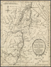
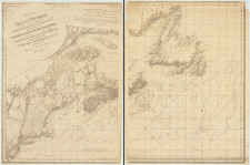
Finely detailed map showing part of the Colony of New York between Albany and Fort Ticonderoga during the American Revolution.
The map shows towns, roads, rivers, mills, Fort Massachusetts, Ft. Miller, Ft. Hardy, Fort Edward, Ft. Amherst, Ft. Anne, Ft. George and Ft.Ticonderoga.
At the bottom right, the NB notes "Situations uncertain have a Line drawn under the name." These include:
- Bennington (Battle of Bennington, August 16, 1777)
- Santcoick (Probably Walloomsac, New York on the Hoosick River)
- Castletown
- Huberton (Battle of Hubbardton, July 7, 1777)
Reference
Jolly, D.C. (Brit Per) LOND-320.
![[ Inhabitants of New Netherlands ] Einwohner in Neu Niederland](https://storage.googleapis.com/raremaps/img/small/94087.jpg)