
This item has been sold, but you can enter your email address to be notified if another example becomes available.


|
||

|

|
|

|
Stock# 82354
Description
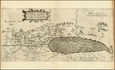
Striking early map of the Holy Land, engraved in London by John Goddard.
The map extends from Misrepoth, Heliopolis, Madon and Damascus in the North to Rinocolura, Zezron, Admah and Gomorah (which are shown a burning in the middle of the Dead Sea) in the South.
The map extends the length of the Jordan River and includes numerous place names and the coat of arms of the 12 Tribes From Fuller's A Pisgah-Sight of Palestine and the confines there of with the history of the Old and New Testament acted thereon, by William Marshall.
Condition Description
Two sheets, joined as issued. Minor loss along left side.
![(Nuremberg Chronicle Leaf) [Moses and the Burning Bush]](https://storage.googleapis.com/raremaps/img/small/98578.jpg)
![A view of the division of the land of Canaan and the situation of the city and sanctuary [Manuscript map]](https://storage.googleapis.com/raremaps/img/small/87556.jpg)