|
||

|

|
|

|
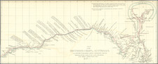
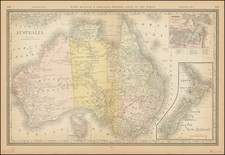
James Cook Navigates the Great Barrier Reef
Nice example of Captain James Cook's map of a portion of the east coast of Australia, from the Official Account of the Cook's First Voyage.
Oriented with west at the top, Cook's map is the first printed map to concentrate on a section of Australia's east coast, covering the Queensland coast from Cape Tribulation to the Endeavour Straits. The chart meticulously tracks Cook's course along the East Coast, including the details of the Labryrinth, where Cook's chart hit a reef on the Great Barrier Reef
Cook's first voyage (1768-1771)
The Transit of Venus is one of the rarest predictable astronomical phenomena, occurring twice in eight years and then not again for over one hundred years (in a 243-year cycle). Observing the time it takes for Venus to transit across the sun can help to calculate the size of the solar system and the distance from the Earth to the Sun. In 1761, scientific societies sought to record the Transit from posts around the world. However, many of the observations were flawed or thwarted by the weather, especially those arranged, in haste, by the Royal Society of London. Determined to not repeat the same mistake, the Royal Society planned a South Sea voyage to view the 1769 Transit in concert with the Royal Navy, as the southern Pacific would be one of the places where the Transit was visible.
The Admiralty chose Lieutenant James Cook to command the expedition, based on his aptitude for charting and instrumentation. He was joined by Joseph Banks, a wealthy young botanist, and his retinue of scientists and artists. In addition to observing the Transit, Cook was secretly instructed to seek out and claim any potentially-useful territory or resources that his ship, Endeavour, came across.
Cook and his crew sailed from Plymouth on August 25, 1768. It sailed south, to Tierra del Fuego, and then to its destination for the Transit: Tahiti. There, three groups observed the Transit, although their results were imprecise. When the Endeavour left Tahiti in July 1769; on board was a new member of the party, the Rai’aitean priest and navigator Tupaia, along with his servant, Taiato.
The ship headed south, arriving in New Zealand in early October. There, Tupaia found that he could understand and speak with the local people, the Māori. However, this did not prevent several violent incidents that resulted in deaths. While charting the coastline, Cook and the voyage astronomer, Charles Green, observed the Transit of Mercury. The ship sailed round the southern tip of the South Island, proving it was not connected to a southern continent.
Next, the Endeavour set out east, encountering the east coast of Australia in April 1770. They were the first Europeans to do so. After stopping at a place they called Botany Bay, the ship turned north, skirting the coast. Endeavour ran aground on the Great Barrier Reef; while the ship was saved, they had to stop for repairs at Waalumbaal Birri, or Endeavour River. Here, the Europeans saw their first kangaroo and learned its name from the local people, the Guugu Yimithirr. They nearly ran aground again, but narrowly averted disaster and made for Jakarta, then known as Batavia.
In Batavia, many members of the crew became ill. More than two dozen men, including Sydney Parkinson, the voyage artist, the aforementioned Charles Green, and Tupaia, died in Jakarta or at sea soon thereafter. Weakened, the Endeavour called at the Cape of Good Hope and returned to the Thames in July 1771.
![[Manuscript map of Terra Australis]](https://storage.googleapis.com/raremaps/img/small/92054.jpg)