|
||

|

|
|

|
Stock# 82300
Description
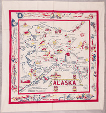
Highly detailed map of Alaska, published in Seattle by Kroll Company, one of the leading western map publishers.
The map is overprinted in red to show the newest roads and newly established air routes, one of the earliest maps to depict air service in Alaska.
The map provides remarkable internal details and includes the results of the 1930 Alaskan Census, locating hundreds of places and including populations for some (the total population of the state in 1930 was 59,278).
This example lacks the additional onlaid slip that updates populations to 1946.
The Legend provides symbols detailing many interesting features, including:
- Valdez-Fairbanks Auto Road
- Railroads
- Wagon Roads
- Sled Roads
- Pack Trails
- Steamship Lines
- Road Houses
- Post offices
- Villages and Settlements
- Mines
- Gold & Silver Lodes
- Gold Placers
- Radio & Telegraph Stations
- Lighthouses
- Schools
- Canneries
- Oil Seapage
- Cable Lines
- New Roads (in red)
- Scheduled Airways
Condition Description
Folding map, mounted in original printed paper wrappers.
![[ California To Alaska -- Northwest Passage ] Quivirae Regnu cum alijs versus Borea](https://storage.googleapis.com/raremaps/img/small/60083.jpg)