|
||

|

|
|

|
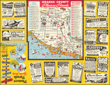
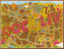
Interest in the Spanish and Mexican Ranchos and the lack of good maps from the period make promotional pieces of this nature a wonderful revelation.
Pictorial map of Orange County in California showing the Spanish and Mexican land grant Ranchos, prior to California become a part of theUnited States. Contemporary locations are denoted, such as Irvine, Laguna Beach, Sunset Beach, Anaheim, Brea, Santa Ana, and Newport Beach. La Mission San Juan Capistrano is illustrated.
The ocean is decorated with whimsical illustrations, including a fish, whale, starfish, mythical creature, and a ship. Another large illustration shows a man in traditional Spanish dress playing the guitar and riding a donkey. The map was prepared for the Title Insurance and Trust Company, Los Angeles. The company issued this promotional map, presumably to encourage the purchase of land in Orange County using the firm's services, as well as to provide a resource for homeowners interested in the early history of their properties.
Lowell Butler created pictorial maps for publications of the Automobile Club of Southern California in the mid-1950s, including A Map of the Marked Historical Sites of California (c. 1952), Outdoor Play Places of California (c. 1954) and Spanish California: A Map of the Missions, Presidios, Pueblos and Some of the More Interesting Ranchos (c. 1956).
![[Esparto, California] Map Showing Subdivisions of the Bonynge Tract and the Position of the Townsite of Esperanza Yolo County California... 1887-1888](https://storage.googleapis.com/raremaps/img/small/83457.jpg)