|
||

|

|
|

|
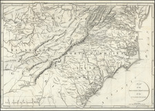
The First English Map of French Louisiana and the Mississippi Valley
Nice example of Senex's map of Louisiana, based upon De L'Isle's seminal map of 1718, which was the first map to name Texas (Tejas).
The map retains the outstanding detail of De L'Isle's map but includes English nomenclature and translations for mot of the notes. The map extends west to the Rio Grande and provides an excellent depiction of Mississippi, Missouri and other major rivers and tributaries in the region, based upon contemporary knowledge.
There are a number of annotations throughout the map, including notes on early exploration and settlement, Spanish trade with the Indians (Gold on the Upper Missouri!), and early routes of the Spanish and French explorers in the region. Florida is depicted as an Archipelago. Many Indian Villages are shown, along with the Promiscuous Nations and Nations Destroyed. "Chicagou" appears on Lake Michigan. Many early mines and forts are depicted.
De L'Isle's Map of Louisiana
De L'Isle 's map is "the first large-scale map accurately showing the lower Mississippi River and surrounding areas” and the first printed map to properly locate and name ‘Texas.’ “The most important notation to Texas history [on the map]... was that appearing along the Trinity: ‘Mission de los Tiejas, etablie in 1716.’ . . . This phrase marked the first appearance of a form of the name Texas on a printed map, and thus Delisle has received proper credit for establishing Texas as a geographic place name.”
De L'Isle's map is one of the most widely copied and influential maps ever produced. The map contains the first indications of the explorations of De Soto, Cavelier, Tonty, Moscoso and Denis. It included the best depiction of the Mississippi River to date, for the first time presenting a roughly accurate delineation of its entire length, as well as a semblance of accuracy about many of its tributaries. It was also the first map to include the name Texas with the legend "Mission de los Teijas," indicating a Mission established in 1716. As noted by Cohen:
A significant map in Western American history and a work by one of the greatest mapmakers of all time. The map revealed for the first time the importance of the Missouri River and gave the most accurate delineation of the Mississippi Valley up to that time… [Delisle's] passion for pure scientific accuracy is reflected on his maps. If geographic information had not been directly observed by a reliable source, he refused to acknowledge it. Many longstanding myths and errors that had been passed from mapmaker to mapmaker for generations were suddenly absent on Delisle's maps.
A seminal map for Americana collectors.
John Senex (1678-1740) was one of the foremost mapmakers in England in the early eighteenth century. He was also a surveyor, globemaker, and geographer. As a young man, he was apprenticed to Robert Clavell, a bookseller. He worked with several mapmakers over the course of his career, including Jeremiah Seller and Charles Price. In 1728, Senex was elected as a Fellow of the Royal Society, a rarity for mapmakers. The Fellowship reflects his career-long association as engraver to the Society and publisher of maps by Edmund Halley, among other luminaries. He is best known for his English Atlas (1714), which remained in print until the 1760s. After his death in 1740 his widow, Mary, carried on the business until 1755. Thereafter, his stock was acquired by William Herbert and Robert Sayer (maps) and James Ferguson (globes).
![[School Girl Map] United States by Betsey C. Converse](https://storage.googleapis.com/raremaps/img/small/66109.jpg)