![Indian Territory [with Colorado on verso] By Samuel Augustus Mitchell Jr.](https://storage.googleapis.com/raremaps/img/small/74706.jpg)


|
||

|

|
|

|
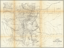
Highly detailed map of Colorado [and Indian Territory on the back side], published by Samuel Augustus Mitchell Jr.
Indian Territory
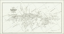
Mitchell's map of Indian Territory offers a detailed and accurate depiction of the region during a crucial time in its history. Indian Territory, which is now the state of Oklahoma, was a semi-autonomous region established by the United States government in the 19th century for the settlement of Native American tribes.
During the 1870s and early 1880s, Indian Territory was a rapidly changing region. In 1871, the United States government signed a treaty with the Five Civilized Tribes, which allowed them to remain in Indian Territory and to retain their semi-autonomous status. However, the government also continued to negotiate with other Native American tribes, and by the late 1870s, Indian Territory was home to a diverse population of Native American, African American, and European American settlers.
The map locates town and other settlements in the territory, as well as the location of the various Native American reservations. as well as the geography and topography of the region, including rivers, mountains, and other geographical features, tge boundaries of the various Native American reservations (with data on various treaties), as well as the location of the major military forts and other government installations. The location of the various transportation routes are also shown.
Colorado
In the 1870s and 1880s, Colorado was a rapidly changing and growing state. One of the key events in Colorado's history during this time was the mining boom in the southwestern part of the state. In the 1870s, a series of gold and silver strikes in the San Juan Mountains sparked a rush of miners and prospectors to the region. By the 1880s, the southwestern part of the state was home to a thriving mining industry, and a number of new towns and cities had sprung up in the area.
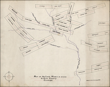
The map shows the location of the major mining towns and cities, including Silverton, Ouray, and Lake City, along with details in the major mining districts, including the San Juan Mountains and the Animas River Valley, including the location of Telluride, Ophir, San Miguel, Placerville and a number of other newly created towns.
Samuel Augustus Mitchell Jr. inherited the Mitchell Company from his father in 1860. For over thirty years, the company had specialized in the production of school atlases and wall maps of America. They were one of the pioneers on engraving on steel plates. In 1860, Samuel Jr. released the New General Atlas, which had been compiled in house and replaced a previous atlas by Tanner. The elder Mitchell died in 1868 and Samuel Jr. continued the business until the 1890s. At its height, the Mitchell Company employed 250 people and sold 400,000 publications annually.
![(Western Photographs) [Collection of 35 Albumen Photographs by Isaiah Taber, Norman Reed, W.H. Jackson and others: California, Arizona, New Mexico, Colorado]](https://storage.googleapis.com/raremaps/img/small/90506.jpg)