


|
||

|

|
|

|
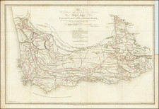
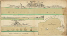
The First Scientific Mapping of South Africa and First To Record The Extinction of A Species
Scarce dedication published copy of John Barrow's remarkable map of South Africa, engraved by Samuel Neele in London.
John Barrow came to Cape Colony to serve as Secretary to Lord Macartney. Upon his arrival, he discovered that there were no truly reliable maps of the British Colony maps of the colony. In answer to Lord Macartney's concerns that the British were "shamefully ignorant even of the geography of the country," Barrow set about to produce such a map. As noted by Eli Liebenberg:
When Lord Macartney became Governor of the Cape in 1797, he chose John Barrow as one of his private secretaries. During the years 1797-99 Barrow undertook three journeys into the interior and produced a map which was unquestionably the best map of the country to date.
Barrow used his time traveling through the Colony to establish a reliable set of latitude readings every thirty-five miles, using dead reckoning to establish longitude. The resulting map s a landmark in the history of mapping of South Africa, shaping the subsequent maps by Aaron Arrowsmith and other leading mapmakers for the next 4 decades.
The map is also noteworthy for its unusually detailed references to the wildlife of Cape Colony, including a reference to the extinction of the Blue Antelope nearly the modern Bontebok Park.
Rarity
While a version of Barrow's map with a similar title but plain lettering appears occasionally on the market, this example, dedicated to the Early of Macartney is quite rare on the market. The map is not listed in AMPR.
![[South Africa / Namibia / Angola] Coste Occidentale D'Afrique Depuis le XIe. Degre De Latitude Meridional, Jusqua'au Cap de Bonne Esperance Tiree de la Carte de l'Ocean Meridional . . . 1739](https://storage.googleapis.com/raremaps/img/small/77033.jpg)