|
||

|

|
|

|
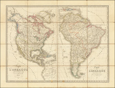
Fine 17th Century Example of the Original Beaver Map -- First French Wall Map of America To Report on Hennepin's Discoveries
Rare example of the "Original Beaver Map," one of the most influential maps of North America published at the end of the 17th Century.
De Fer's wall map of America is one of the most important and well regarded maps of its time, incorporating late 17th Century Jesuit information from the Mississippi River and Great Lakes regions, as well as a massive depiction of California as an Island. The map is surrounded by images of natives and scenes from varying parts of the continents including two industries important to the old world, Beavers, for their pelts and the Newfoundland cod fishery. The two text panels describe the various regions including Louisiana, Florida and the English colonies.
The map is the first French wall map of America to highlight the French fur trading expansion into the regions west of the Great Lakes and the Upper Mississippi region. The depiction of the Illinois River, with its short Portage to the Chicago area and "Lac Illinois" (Lake Michigan) and similar treatment of the Ohio River, with a short portage to connect the river to Lake Erie, sends a clear signal supporting French trading interests in the region, with several French Forts (Fort Miamis, Fort Crevecoeur, Fort Tua, Fort Sauvagve and Fort du Prudhomme and an unnamed Fort on Lake Erie), as well as the numerous Jesuit Missions in the region provide additional support for fur trading and other French interests in the region.
The map is the first map to include a vignette of Beavers in Canada, which was later used by Herman Moll for his famous Beaver Map of the British Dominions in North America. According to Dahl, de Fer's map was engraved by van Loon, but the decorative vignettes were all designed, etched and engraved by Nicolas Guerard. The beaver scene shows dozens of industrious creatures against a backdrop of Niagara Falls, which Guerard most likely based on Hennepin's first printed view of the falls, published a year earlier in 1697.
The present example is also one of the few states to show the course of the Lower Mississippi River based upon the discoveries of La Salle, with the mouth of the Mississippi mistakenly shown far to the southwest of its true location, prior to the changes made following De L'Isle's maps of 1700 and 1703 significantly revised the geography of the region. After 1705, a large section of the Lower Mississippi River is removed and largely left blank between the Ouabache and the Sableoniere Rivers, with the Ohio trending far south of its true course.
States of the Map and Rarity
Burden has identified at least 7 states of the map, with two states of the 1698 map from, both of which are extremely rare. Dahl calls it almost unknown. Neither Tooley nor McLaughlin cite any edition prior to 1705. We note states dated 1698 (2 states), 1705, 1713, 1716, 1717 and 1739.
The present example is the second state, which adds a decorative vignette surrounding the dedication to the Dauphin above the vignette of the Peruvian inhabitants at the bottom left, but retains the date of 1698 and is otherwise identical to state 1.
This is the first example of state 2 we have seen on the market in the past 30 years.
We note only one example of state 1 in AMPR, offered by Arkway in 2006 at $145,000, with the same example re-offered in 2010 by Cohen & Taliaferro for $185,000 (described as a "pristine" example in original outline color).
The popular misconception of California as an island can be found on European maps from the sixteenth through the eighteenth centuries. From its first portrayal on a printed map by Diego Gutiérrez, in 1562, California was shown as part of North America by mapmakers, including Gerardus Mercator and Abraham Ortelius. In the 1620s, however, it began to appear as an island in several sources. While most of these show the equivalent of the modern state of California separated from the continent, others, like a manuscript chart by Joao Teixeira Albernaz I (ca. 1632) now in the collection of the National Library of Brasil shows the entire western half of North Americas as an island.
The myth of California as an island was most likely the result of the travel account of Sebastian Vizcaino, who had been sent north up the shore of California in 1602. A Carmelite friar, Fray Antonio de la Ascensión, accompanied him. Ascension described the land as an island and around 1620 sketched maps to that effect. Normally, this information would have been reviewed and locked in the Spanish repository, the Casa de la Contratación. However, the manuscript maps were intercepted in the Atlantic by the Dutch, who took them to Amsterdam where they began to circulate. Ascensión also published descriptions of the insular geography in Juan Torquemada’s Monarquia Indiana (1613) (with the island details curtailed somewhat) and in his own Relación breve of ca. 1620.
The first known maps to show California as an island were on the title pages of Antonio de Herrera’s Descripción de las Indias Occidentales (1622) and Jacob le Maire's Spieghel Der Australische Navigatie (1622). Two early examples of larger maps are those by Abraham Goos (1624) and another by Henry Briggs, which was included in Samuel Purchas’ Hakluytus Posthumus or Purchas his Pilgrimes (1625). In addition to Briggs and Goos, prominent practitioners like Jan Jansson and Nicolas Sanson adopted the new island and the practice became commonplace. John Speed’s map (1626-7), based on Briggs’ work, is well known for being one of the first to depict an insular California.
The island of California became a fixture on mid- and late-seventeenth century maps. The island suggested possible links to the Northwest Passage, with rivers in the North American interior supposedly connecting to the sea between California and the mainland. Furthermore, Francis Drake had landed in northern California on his circumnavigation (1577-80) and an insular California suggested that Spanish power in the area could be questioned.
Not everyone was convinced, however. Father Eusebio Kino, after extensive travels in what is now California, Arizona, and northern Mexico concluded that the island was actually a peninsula and published a map refuting the claim (Paris, 1705). Another skeptic was Guillaume De L’Isle. In 1700, De L’Isle discussed “whether California is an Island or a part of the continent” with J. D. Cassini; the letter was published in 1715. After reviewing all the literature available to him in Paris, De L’Isle concluded that the evidence supporting an insular California was not trustworthy. He also cited more recent explorations by the Jesuits (including Kino) that disproved the island theory. Later, in his map of 1722 (Carte d’Amerique dressee pour l’usage du Roy), De L’Isle would abandon the island theory entirely.
Despite Kino’s and De L’Isle’s work, California as an island remained common on maps until the mid-eighteenth century. De L’Isle’s son-in-law, Philippe Buache, for example, remained an adherent of the island depiction for some time. Another believer was Herman Moll, who reported that California was unequivocally an island, for he had had sailors in his offices that claimed to have circumnavigated it. In the face of such skepticism, the King of Spain, Ferdinand VII, had to issue a decree in 1747 proclaiming California to be a peninsula connected to North America; the geographic chimera, no matter how appealing, was not to be suffered any longer, although a few final maps were printed with the lingering island.
Nicholas de Fer (1646-1720) was the son of a map seller, Antoine de Fer, and grew to be one of the most well-known mapmakers in France in the seventeenth century. He was apprenticed at twelve years old to Louis Spirinx, an engraver. When his father died in 1673, Nicholas helped his mother run the business until 1687, when he became the sole proprietor.
His earliest known work is a map of the Canal of Languedoc in 1669, while some of his earliest engravings are in the revised edition of Methode pour Apprendre Facilement la Geographie (1685). In 1697, he published his first world atlas. Perhaps his most famous map is his wall map of America, published in 1698, with its celebrated beaver scene (engraved by Hendrick van Loon, designed by Nicolas Guerard). After his death in 1720, the business passed to his sons-in-law, Guillaume Danet and Jacques-Francois Benard.